Category:Old maps of Le Château-d'Oléron
Subcategories
This category has only the following subcategory.
Media in category "Old maps of Le Château-d'Oléron"
The following 8 files are in this category, out of 8 total.
-
 Plan du projet de la citadelle d'Oléron.jpg 3,822 × 2,412; 939 KB
-
 Plan de la citadelle d'Oléron 1685.jpg 9,609 × 7,411; 8.64 MB
-
 Plan de la citadelle d'Oléron 1692.jpg 7,137 × 5,421; 4.01 MB
-
 Plan de la citadelle d'Oléron 1693.jpg 6,326 × 5,043; 3.66 MB
-
 Plan de la citadelle d'Oléron (2).jpg 8,304 × 6,008; 7.11 MB
-
 Plan de la citadelle d'Oléron pour les projets de 1752.jpg 5,136 × 3,931; 2.31 MB
-
 Plan de la citadelle d'Oléron 1753.jpg 6,439 × 4,113; 2.91 MB
-
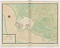
 Plan de la citadelle d'Oléron.jpg 8,974 × 6,786; 8.74 MB


.jpg)


