Category:Old maps of Linz
Subcategories
This category has only the following subcategory.
M
Media in category "Old maps of Linz"
The following 12 files are in this category, out of 12 total.
-

-
 Franziszeische Landesaufnahme 01.png 561 × 411; 515 KB
-
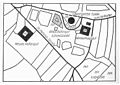
 Lage des Kaplanhofes nach dem Franziszeischem Kataster.JPG 579 × 511; 42 KB
-
 Lintz im Grund (Merian).jpg 1,791 × 1,146; 680 KB
-
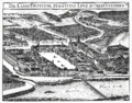
 Lintz im prospect (Merian).jpg 1,545 × 948; 429 KB
-
 Linz (Vischer).png 2,392 × 1,879; 1.2 MB
-
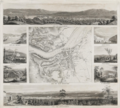 Linz und seine Umgebungen Mitte 19Jh.png 2,797 × 2,514; 10.42 MB
-
 Linzer Donaubrücke (Vischer).png 986 × 685; 904 KB
-
 Lonstorfer Turm-neu.jpg 1,473 × 1,044; 124 KB
-
 Meyer‘s Zeitungsatlas 047 – Erz-Herzogthum Oesterreich- Ob der Enns.jpg 7,372 × 6,210; 12.64 MB
-
 OHM - Karte Bistum Passau 3 Linz.jpg 2,560 × 1,712; 1.54 MB
-
 Zween Prospect der Statt Lintz (Merian).jpg 1,528 × 2,388; 1.07 MB
_(14778900605).jpg)


.jpg)
.jpg)
.png)

.png)


.jpg)