Category:Old maps of Lowell, Massachusetts
Subcategories
This category has only the following subcategory.
Media in category "Old maps of Lowell, Massachusetts"
The following 21 files are in this category, out of 21 total.
-
-
 1841 map of Lowell, Massachusetts.tiff 5,000 × 3,322; 15.84 MB
-
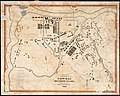
 Map of the city of Lowell - surveyed in 1841 by order of the municipal authorities LOC 2012592604.tif 10,992 × 9,505; 298.92 MB
-
 1845 map of Lowell, Massachusetts.png 3,201 × 2,745; 2.17 MB
-
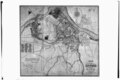
 1846 sketch of proposed canal from Pawtucket Dam to Western Canal; Lowell, MA.tiff 5,000 × 3,208; 15.3 MB
-
 Plan of the city of Lowell, Massachusetts (2675392914).jpg 2,000 × 1,728; 3.44 MB
-
 1850 Plan of the city of Lowell, Massachusetts BPL 11051.png 963 × 745; 1.19 MB
-
 Plan of land in Ayers New-City, Lowell, Mass. (4587187052).jpg 1,345 × 2,000; 2.07 MB
-
 1876 bird's eye view of Lowell, Massachusetts.tiff 5,000 × 3,240; 15.45 MB
-
 1876 bird's eye view of Lowell, Massachusetts; colored.jpg 9,768 × 7,272; 19.3 MB
-
 Map of the city of Lowell, Massachusetts LOC 2011592157.jpg 7,538 × 5,729; 5.76 MB
-
 Map of the city of Lowell, Massachusetts LOC 2011592157.tif 7,538 × 5,729; 123.55 MB
-
 Belvidere Park, Lowell, Mass. (4586561917).jpg 9,280 × 5,760; 8.13 MB
-

-
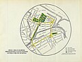
 1968 map of proposed Lowell Connector Extension.jpg 1,206 × 1,557; 269 KB
-

-

-
 City of Lowell (9137935278).jpg 799 × 562; 108 KB
-
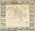
 Lowell, the City Beautiful on the Merrimack.jpg 3,971 × 2,966; 1.13 MB
-

-
 View of Lowell, Mass. (2673757671).jpg 2,000 × 1,378; 2.28 MB


.jpg)

.jpg)


.jpg)


.jpg)


.jpg)