Category:Old maps of Missouri in the American Civil War
States of the United States: Alabama · Arkansas · Florida · Georgia · Kentucky · Louisiana · Maryland · Mississippi · Missouri · North Carolina · Pennsylvania · South Carolina · Tennessee · Texas · Virginia – Washington, D.C.
Media in category "Old maps of Missouri in the American Civil War"
The following 10 files are in this category, out of 10 total.
-
 242 of 'History of the American Civil War, etc' (11059642934).jpg 923 × 1,078; 231 KB
-
 Abraham Lincoln - a history (1914) (14761985221).jpg 2,240 × 2,000; 743 KB
-
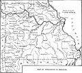
 Battle Sites of the Civil War in Missouri.jpg 1,480 × 1,710; 730 KB
-
-

-

-

-
 NewMadridBend.jpg 450 × 676; 200 KB
-
 The Mississippi Valley in the Civil War (1900) (14576038128).jpg 2,896 × 1,772; 358 KB
-
 Wilsons Creek.jpg 1,811 × 2,790; 2.25 MB
.jpg)
_(14761985221).jpg)


_(14576038128).jpg)
