Category:Old maps of Vancouver Island
Media in category "Old maps of Vancouver Island"
The following 21 files are in this category, out of 21 total.
-
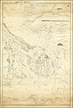
 (Map showing coast of northwestern portion of Vancouver Island). LOC 91683690.jpg 5,290 × 6,643; 3.27 MB
-

-

-

-

-

-

-

-

-

-

-
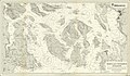
 Admiralty Chart No 2689 Haro and Rosario Straits Surveyed By Captn. G.H. Richards, Published 1859.jpg 16,075 × 23,895; 66.24 MB
-
-

-
 Bancroft's Works History of the Northwest Coast vol 1 (1884) (14577962788).jpg 2,493 × 3,351; 2.15 MB
-
-
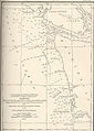
 FMIB 44345 Summer Fishing Grounds of Seattle Halibut Fleet.jpeg 791 × 855; 82 KB
-

-

-

-
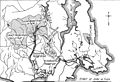 Sooke Water System 1915.jpg 1,834 × 1,249; 553 KB
._LOC_91683690.jpg)

.jpg)
.jpg)
.jpg)
.jpg)
.jpg)
_(1899)_(19995533784).jpg)
_(1899)_(19997206773).jpg)
_(1899)_(20430124030).jpg)


_Surveyed_by_Captn._G.H._Richards_and_the_Officers_of_the_H.M.S._Plumper_1858,_Published_1864,_Corrections_to_1865.jpg)
_(14577962788).jpg)


_(With_a_map.)%27_(11248039595).jpg)
_(With_a_map.)%27_(16590217435).jpg)

