Category:Old maps of Virginia
States of the United States: Alabama · Alaska · Arizona · Arkansas · California · Colorado · Connecticut · Delaware · Florida · Georgia · Hawaii · Idaho · Illinois · Indiana · Iowa · Kansas · Kentucky · Louisiana · Maine · Maryland · Massachusetts · Michigan · Minnesota · Mississippi · Missouri · Montana · Nebraska · Nevada · New Hampshire · New Jersey · New Mexico · New York · North Carolina · North Dakota · Ohio · Oklahoma · Oregon · Pennsylvania · Rhode Island · South Carolina · South Dakota · Tennessee · Texas · Utah · Vermont · Virginia · Washington · West Virginia · Wisconsin · Wyoming – District of Columbia: Washington, D.C.
Guam · Northern Mariana Islands · Puerto Rico
Guam · Northern Mariana Islands · Puerto Rico
Subcategories
This category has the following 14 subcategories, out of 14 total.
Media in category "Old maps of Virginia"
The following 200 files are in this category, out of 2,294 total.
(previous page) (next page)-

-
 (Battery no. 3) ; - outwork no. 1 ; outwork no. 2. LOC lva0000110.jpg 4,872 × 3,907; 1.24 MB
-
 (Battery no. 3) ; - outwork no. 1 ; outwork no. 2. LOC lva0000110.tif 4,872 × 3,907; 54.46 MB
-

-

-

-

-

-

-
-

-

-
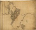
 (Map of Fairfax and Alexandria counties, Virginia, and parts of adjoining counties) LOC 2006627694.tif 10,421 × 8,215; 244.93 MB
-
 (Map of Greene County, Va.). LOC 2002627445.jpg 10,180 × 10,338; 14.09 MB
-
 (Map of Greene County, Va.). LOC 2002627445.tif 10,180 × 10,338; 301.1 MB
-

-

-
 (Map of King William County, Va) LOC 2012589214.jpg 8,607 × 6,060; 6.2 MB
-
 (Map of King William County, Va) LOC 2012589214.tif 8,607 × 6,060; 149.23 MB
-
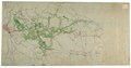
 (Map of Louisa County, Virginia) LOC 2003683404.jpg 8,040 × 6,574; 7.86 MB
-
 (Map of Louisa County, Virginia) LOC 2003683404.tif 8,040 × 6,574; 151.22 MB
-

-

-
 (Map of Orange County, Va.). LOC 2002627458.jpg 8,984 × 4,932; 5.86 MB
-
 (Map of Orange County, Va.). LOC 2002627458.tif 8,984 × 4,932; 126.77 MB
-
 (Map of part of Fairfax and Prince William Counties, Virginia). LOC 99446518.jpg 7,352 × 5,827; 5.15 MB
-
 (Map of part of Fairfax and Prince William Counties, Virginia). LOC 99446518.tif 7,352 × 5,827; 122.57 MB
-
 (Map of part of Virginia, West Virginia, and Maryland). LOC 2006635253.jpg 5,213 × 7,146; 4.31 MB
-
 (Map of part of Virginia, West Virginia, and Maryland). LOC 2006635253.tif 5,213 × 7,146; 106.58 MB
-

-

-

-
 (Map of parts of Fauquier, Prince William, and Rappahannock counties, Va.). LOC 2002627440.tif 5,360 × 4,582; 70.27 MB
-
 (Map of parts of Orange, Louisa, and Spotsylvania counties, Va.). LOC 2003629691.jpg 2,612 × 2,070; 654 KB
-
 (Map of parts of Orange, Louisa, and Spotsylvania counties, Va.). LOC 2003629691.tif 2,612 × 2,070; 15.47 MB
-

-
-
 (Map of Prince Edward County, Va.). LOC 2002627461.jpg 3,686 × 2,981; 1.59 MB
-
 (Map of Prince Edward County, Va.). LOC 2002627461.tif 3,686 × 2,981; 31.44 MB
-
 (Map of Rockbridge County, Virginia). LOC 2005625189.jpg 2,318 × 2,775; 850 KB
-
 (Map of Rockbridge County, Virginia). LOC 2005625189.tif 2,318 × 2,775; 18.4 MB
-

-
 (Map of Shenandoah County between Mt. Jackson and New Market, Virginia). LOC 2005625057.tif 1,697 × 2,638; 12.81 MB
-
 (Map of Spotsylvania County, Va.). LOC 2002627467.jpg 5,426 × 7,544; 4.23 MB
-
 (Map of Spotsylvania County, Va.). LOC 2002627467.tif 5,426 × 7,544; 117.11 MB
-
 (Map of the Battle of Chancellorsville, Va). LOC gvhs01.vhs00389.jpg 1,854 × 1,235; 222 KB
-
 (Map of the Battle of Chancellorsville, Va). LOC gvhs01.vhs00389.tif 1,854 × 1,235; 6.55 MB
-

-

-
-

-

-
-

-

-
 (Map of the vicinity of Strasburg, Virginia). LOC 2005625097.jpg 5,141 × 4,013; 2.6 MB
-
 (Map of the vicinity of Strasburg, Virginia). LOC 2005625097.tif 5,141 × 4,013; 59.03 MB
-

-

-

-

-
 (Sketch of action near New Cold Harbor, Va.) - NARA - 305594.tif 3,600 × 2,328; 23.98 MB
-
 (Sketch of the United States Ford on the Rappahannock River). LOC 2005625047.jpg 1,719 × 2,132; 423 KB
-
 (Sketch of the United States Ford on the Rappahannock River). LOC 2005625047.tif 1,719 × 2,132; 10.49 MB
-
 (White House to Harrisons Landing). LOC lva0000210.tif 9,594 × 5,044; 138.45 MB
-
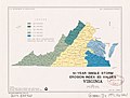 10-year single-storm erosion index (E I) values Virginia LOC 2014588420.jpg 4,363 × 3,302; 1.23 MB
-
 10-year single-storm erosion index (E I) values Virginia LOC 2014588420.tif 4,363 × 3,302; 41.22 MB
-
 105 of 'From Gettysburg to the Rapidan. The Army of the Potomac, etc' (11162176744).jpg 3,594 × 3,807; 2.77 MB
-
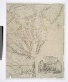
 Tierra nveva (NYPL b15307938-434490)(c).jpg 4,160 × 2,912; 1.93 MB
-
 Tierra nveva (NYPL b15307938-434490).jpg 4,899 × 3,856; 2.54 MB
-
 Tierra nveva (NYPL b15307938-434490).tiff 4,899 × 3,856; 54.08 MB
-
 Tierra nveva. NYPL434490.tiff 5,251 × 4,256; 63.98 MB
-
 Tierra nveva (NYPL b15307937-434500)(c).jpg 4,416 × 3,320; 2.62 MB
-
 Tierra nveva (NYPL b15307937-434500).jpg 5,251 × 4,256; 3.4 MB
-
 Virginia map 1606.jpg 3,500 × 2,709; 6.05 MB
-
 Map of Virginia - Travels through Virginia (1618), ff.14v-15 - BL Sloane MS 1622.jpg 1,365 × 1,101; 938 KB
-
-
 Augustin Heřman's map of the Chesapeake Bay.jpg 817 × 686; 43 KB
-
 Augustine Herrman 1670 Map Virginia Maryland.jpg 3,202 × 2,551; 1.61 MB
-
 Augustine Herrman 1670 Map Virginia Maryland.tiff 12,805 × 10,204; 373.86 MB
-
 Virginia and Maryland by Augustine Herman, 1736.jpg 3,112 × 5,228; 2.82 MB
-
 1676 John Speed Map of Carolina - Geographicus - Carolina-speed-1676.jpg 5,000 × 3,783; 5.23 MB
-
 1707-Leiden.jpg 1,400 × 2,024; 580 KB
-
 Indians NW of South Carolina.jpg 1,770 × 1,217; 294 KB
-

-

-
 Alexandria Winchester 1776.jpg 1,208 × 704; 247 KB
-
 A correct map of Virginia (NYPL b15376651-433675).jpg 6,300 × 5,248; 7.59 MB
-
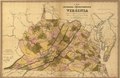
 1838 Bradford Map of Virginia - Geographicus - Virginia-bradford-1838.jpg 3,500 × 2,712; 2.73 MB
-
 1848 Greenleaf Map of Virginia - Geographicus - Virginia-greenleaf-1848.jpg 3,500 × 2,951; 2.99 MB
-

-

-
 1855 Colton Map of Virginia - Geographicus - Virginia-colton-1855.jpg 4,000 × 3,289; 4.08 MB
-

-

-

-

-

-

-

-

-

-
 43 of 'History of the American War' (11068703553).jpg 1,423 × 2,411; 423 KB
-

-

-

-
 549 of 'History of Morgan's Cavalry' (11076310736).jpg 2,233 × 1,280; 435 KB
-
 575 of 'History of Morgan's Cavalry' (11081919925).jpg 1,343 × 2,192; 349 KB
-

-

-

-
-

-
 A map of Amelia County, Virginia LOC 2014588019.jpg 8,237 × 5,798; 6.24 MB
-
 A map of Amelia County, Virginia LOC 2014588019.tif 8,237 × 5,798; 136.64 MB
-
 A map of Fauquier Co. Virginia LOC 2002627437.jpg 5,830 × 7,695; 6.22 MB
-
 A map of Fauquier Co. Virginia LOC 2002627437.tif 5,830 × 7,695; 128.35 MB
-
-

-

-

-

-
-

-

-
-

-

-

-

-

-

-

-
-
-
-

-

-
-

-

-
-

-
 A map of the western parts of the colony of Virginia LOC 2013593293.jpg 1,509 × 2,375; 671 KB
-
 A map of the western parts of the colony of Virginia LOC 2013593293.tif 1,509 × 2,375; 10.25 MB
-
 A Map of the Western parts of the Colony of Virginia, 1754.jpg 952 × 1,544; 1.78 MB
-

-
 A map of Virginia and Maryland (5121163162).jpg 2,000 × 1,543; 3.35 MB
-
 A map of Virginia and Maryland LOC 2013587749.jpg 2,364 × 2,053; 922 KB
-
 A map of Virginia and Maryland LOC 2013587749.tif 2,364 × 2,053; 13.89 MB
-

-

-
 A Map of Washington's Farms at Mt. Vernon (1830 engraving).jpg 4,408 × 2,489; 10.93 MB
-

-

-

-
 A new and accurate map of the province of Virginia in North America (5121162658).jpg 2,000 × 1,649; 3.5 MB
-

-
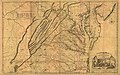
 A new and accurate map of Virginia & Maryland LOC 74693265.jpg 2,769 × 4,264; 2.16 MB
-
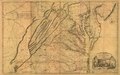
 A new and accurate map of Virginia & Maryland LOC 74693266.jpg 2,892 × 4,192; 2.2 MB
-
-

-
 A new map of Virginia - by Robt. Morden. NYPL433722.tiff 2,658 × 2,296; 17.47 MB
-
 A new map of Virginia from the best authorities (5120558703).jpg 2,000 × 1,529; 3.35 MB
-
 A new map of Virginia from the best authorities LOC 2001627679.jpg 3,147 × 2,529; 1.39 MB
-
 A new map of Virginia from the best authorities LOC 2001627679.tif 3,147 × 2,529; 22.77 MB
-
 A new map of Virginia with Maryland, Delaware & v. LOC 2008621667.jpg 8,836 × 6,307; 12.42 MB
-
 A new map of Virginia with Maryland, Delaware & v. LOC 2008621667.tif 8,836 × 6,307; 159.44 MB
-

-

-

-
 A plan of Alexandria, now Belhaven. LOC 98687108.jpg 4,743 × 3,790; 2.94 MB
-

-
 A plan of Mr. Clifton's neck land platted by a scale of 50 poles to the inch LOC 99464082.tif 8,896 × 6,416; 163.3 MB
-
-

-
-

-
 A Plan of the entrance of Chesapeak Bay, with James and York rivers (2675178594).jpg 2,000 × 1,579; 2.38 MB
-

-

-

-
-

-

-

-

-

-

-
-

-
-
 A topographical map of the city of Richmond and vicinity - from official data LOC 2009575818.tif 6,006 × 8,140; 139.87 MB
-
 Abraham Lincoln and the battles of the Civil War (1886) (14576235090).jpg 2,116 × 2,194; 1.07 MB
-

-

-
 Aero view of Bristol, Va.=Tenn. 1912. LOC 75696638.jpg 10,704 × 8,448; 22.07 MB
-
 Aero view of Bristol, Va.=Tenn. 1912. LOC 75696638.tif 10,704 × 8,448; 258.72 MB
-
 Aero view of Pocahontas, Va. 1911 LOC gm71005382.jpg 8,088 × 5,232; 14.75 MB
-
 Aero view of Pocahontas, Va. 1911 LOC gm71005382.tif 8,088 × 5,232; 121.07 MB
_LOC_2007627337.jpg)
_;_-_outwork_no._1_;_outwork_no._2._LOC_lva0000110.jpg)
._LOC_2005625095.jpg)

_LOC_99439165.jpg)
_LOC_99439135.jpg)
_LOC_2006627694.jpg)
._LOC_2002627445.jpg)
._LOC_2002627451.jpg)
_LOC_2012589214.jpg)
_LOC_2003683404.jpg)
_-_Sheet_no._3._LOC_gvhs01.vhs00356.jpg)
._LOC_2002627458.jpg)
._LOC_99446518.jpg)
._LOC_2006635253.jpg)
._LOC_2002627430.jpg)
._LOC_2002627440.jpg)
._LOC_2003629691.jpg)
_LOC_2002627421.jpg)
._LOC_2002627461.jpg)
._LOC_2005625189.jpg)
._LOC_2005625057.jpg)
._LOC_2002627467.jpg)
._LOC_gvhs01.vhs00389.jpg)
_LOC_gvhs01.vhs00346.jpg)
._LOC_2002627447.jpg)

._LOC_2005625052.jpg)
._LOC_2005625097.jpg)
._LOC_2005625152.jpg)
_LOC_lva0000173.jpg)
._LOC_2005625047.jpg)
_values_Virginia_LOC_2014588420.jpg)
.jpg)
(c).jpg)
.jpg)
(c).jpg)
.jpg)

,_ff.14v-15_-_BL_Sloane_MS_1622.jpg)


%27_(11215561586).jpg)
.jpg)

.jpg)


_-_Geographicus_-_SeaCoastVirginiaNo2-uscs-1853.jpg)


.jpg)
%27_(11218024943).jpg)
_vol._1%27_(11245029513).jpg)
%27_(11218526483).jpg)
.jpg)
.jpg)
.jpg)
.jpg)
.jpg)
.jpg)
.jpg)
.jpg)
%27_(11110961206).jpg)


.jpg)


.jpg)
.jpg)

.jpg)


.jpg)


_Bay,_with_James_and_York_Rivers;_wherein_are_shewn_the_respective_positions_(in_the_beginning_of_October)_1._of_the_British_Army_commanded_by_Lord_Cornwallis,_LOC_gm71000687.jpg)
.jpg)
_1.%E2%81%B0_of_the_British_Army_commanded_by_Lord_Cornwallis_at_LOC_74692131.jpg)
.jpg)


_(14576235090).jpg)


