Category:Old maps of the Banda Islands
Media in category "Old maps of the Banda Islands"
The following 27 files are in this category, out of 27 total.
-
 Kaart van de Banda-eilanden, 1599, RP-P-OB-75.377.jpg 1,342 × 963; 674 KB
-
 Kaart van de Banda-eilanden, 1599, RP-P-OB-75.391.jpg 1,930 × 1,342; 1.32 MB
-
 AMH-6427-NA Map of the Banda islands.jpg 2,400 × 1,685; 476 KB
-
 Dutch ships of Wolfert Harmensz' fleet in Banda ca. 1602.jpg 1,111 × 655; 450 KB
-
 Dutch map of Banda ca. 1602.jpg 1,367 × 1,100; 337 KB
-
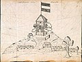 AMH-4736-NA View of the redoubt at Rosingyn.jpg 2,400 × 1,826; 936 KB
-
 AMH-4740-NA Map of Poeloe Run.jpg 2,400 × 1,770; 882 KB
-
 AMH-5493-NA Map of the Banda islands.jpg 2,400 × 1,658; 629 KB
-
 Banda Island Rosingeyn.jpg 1,321 × 2,784; 837 KB
-
 Banda Neira and Gunung Api.jpg 1,852 × 1,417; 600 KB
-
 AMH-5494-NA Map of the islands of Banda.jpg 2,400 × 1,910; 531 KB
-
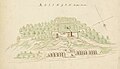
 AMH-4731-NA Fort at Waijer.jpg 2,400 × 1,910; 532 KB
-
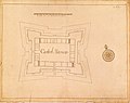 AMH-4721-NA Map of Fort Nassau on Banda Neira.jpg 2,400 × 1,898; 606 KB
-
 Rosingyn 1685.jpg 1,915 × 1,100; 403 KB
-
 AMH-4734-NA Map of the island of Ai, showing Fort Revenge.jpg 2,400 × 1,649; 506 KB
-
 AMH-7216-KB Map of the eastern part of Seram showing the Banda Islands.jpg 2,400 × 1,903; 985 KB
-
 AMH-7219-KB Map of the southeastern part of the Banda islands.jpg 2,400 × 1,954; 674 KB
-
 AMH-6702-NA Map of the Banda islands.jpg 2,400 × 2,229; 465 KB
-

-
 AMH-7993-KB Map of Ceram, Ambon and the Banda islands.jpg 2,400 × 1,381; 616 KB
-
 AMH-7997-KB Map of the Banda islands.jpg 2,400 × 2,162; 1.02 MB
-

-
 AMH-4724-NA Map of the island of Neira showing the Nassouw and Belgica forts.jpg 2,400 × 2,089; 513 KB
-
 Banda islands.jpg 2,960 × 2,105; 2.44 MB
-
-

-
 AMH-5312-NA Map of Ceram, Boura, Amboina and adjacent islands.jpg 2,400 × 1,716; 636 KB


.jpg)


.jpg)
.jpg)

.jpg)