Category:Omaha Creek bridge, Thurston County Rd 25
| Object location | | View all coordinates using: OpenStreetMap |
|---|
Media in category "Omaha Creek bridge, Thurston County Rd 25"
The following 3 files are in this category, out of 3 total.
-
 Omaha Creek bridge Thurston County 25 Rd from S.jpg 2,151 × 916; 949 KB
-
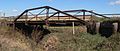 Omaha Creek bridge Thurston County 25 Rd from SW.jpg 2,560 × 1,086; 1.18 MB
-
 Omaha Creek bridge Thurston County 25 Rd from W.jpg 2,560 × 953; 1,010 KB

