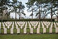
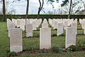
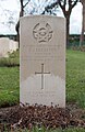
Category:Oostduinkerke Communal Cemetery, Commonwealth Plot
 | |||||
| Upload media | |||||
| Instance of | |||||
|---|---|---|---|---|---|
| Location | Oostduinkerke, Koksijde, Arrondissement of Veurne, West Flanders, Flemish Region, Belgium | ||||
| Quantity buried |
| ||||
 | |||||
Media in category "Oostduinkerke Communal Cemetery, Commonwealth Plot"
The following 14 files are in this category, out of 14 total.
-
 Oostduinkerke Communal Cemetery -10.JPG 1,207 × 1,811; 1.49 MB
-
 Oostduinkerke Communal Cemetery -11.JPG 1,811 × 1,231; 2.46 MB
-
 Oostduinkerke Communal Cemetery -12.JPG 1,112 × 1,811; 1.5 MB
-
 Oostduinkerke Communal Cemetery -13.JPG 1,125 × 1,811; 1.58 MB
-
 Oostduinkerke Communal Cemetery -14.JPG 1,174 × 1,811; 1.67 MB
-
 Oostduinkerke Communal Cemetery -15.JPG 1,212 × 1,811; 1.54 MB
-
 Oostduinkerke Communal Cemetery -16.JPG 1,811 × 1,207; 2.64 MB
-
 Oostduinkerke Communal Cemetery -17 (cropped).JPG 234 × 351; 155 KB
-
 Oostduinkerke Communal Cemetery -17.JPG 1,811 × 1,207; 2.25 MB
-
 Oostduinkerke Communal Cemetery -19.JPG 1,811 × 1,216; 2.41 MB
-
 Oostduinkerke Communal Cemetery -6.JPG 1,811 × 1,221; 3.03 MB
-
 Oostduinkerke Communal Cemetery -7.JPG 1,811 × 1,207; 1.85 MB
-
 Oostduinkerke Communal Cemetery -8.JPG 1,811 × 1,243; 1.71 MB
-
 Oostduinkerke Communal Cemetery -9.JPG 1,179 × 1,811; 1.62 MB


.JPG)


