Category:Oosteinde 11, Sint Jacobiparochie
| Object location | | View all coordinates using: OpenStreetMap |
|---|
building in het Bildt, Netherlands  | |||||
| Upload media | |||||
| Instance of | |||||
|---|---|---|---|---|---|
| Location | Sint Jacobiparochie, Waadhoeke, Friesland, Netherlands | ||||
| Heritage designation |
| ||||
 | |||||
|
This is a category about rijksmonument number 9512
|
| Address |
|
Media in category "Oosteinde 11, Sint Jacobiparochie"
The following 3 files are in this category, out of 3 total.
-
 Oosteinde11 Sint Jacobiparochie.jpg 1,368 × 1,824; 573 KB
-
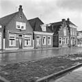 Overzicht voorgevels - Sint Jacobiparochie - 20120559 - RCE.jpg 1,200 × 1,197; 290 KB
-
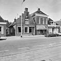 Voorgevel - Sint Jacobiparochie - 20120560 - RCE.jpg 1,192 × 1,200; 318 KB

