Category:Oosterburen 40, Midsland
| Object location | | View all coordinates using: OpenStreetMap |
|---|
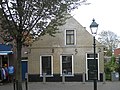
farmhouse in Terschelling, Netherlands  | |||||
| Upload media | |||||
| Instance of | |||||
|---|---|---|---|---|---|
| Location | Midsland, Terschelling, Friesland, Netherlands | ||||
| Located on street |
| ||||
| Heritage designation |
| ||||
 | |||||
|
This is a category about rijksmonument number 35121
|
| Address |
|
Media in category "Oosterburen 40, Midsland"
The following 2 files are in this category, out of 2 total.
-
 Oosterburen 40 te Midsland op Terschelling -01.jpg 4,288 × 3,216; 2.92 MB
-
 Oosterburen 40 te Midsland op Terschelling -02.jpg 4,288 × 3,216; 3.17 MB
