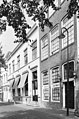
Category:Oosthaven 18, Gouda
| Object location | | View all coordinates using: OpenStreetMap |
|---|
building in Gouda, Netherlands  | |||||
| Upload media | |||||
| Instance of | |||||
|---|---|---|---|---|---|
| Location | Gouda, South Holland, Netherlands | ||||
| Street address |
| ||||
| Located on street | |||||
| Heritage designation |
| ||||
 | |||||
|
This is a category about rijksmonument number 16885 |
| Address |
|
Media in category "Oosthaven 18, Gouda"
The following 12 files are in this category, out of 12 total.
-
 2011-09-28 Gouda 099.JPG 2,736 × 3,648; 3.44 MB
-
 2011-09-28 Gouda 100.JPG 2,736 × 3,648; 3.46 MB
-
 Overzicht - Gouda - 20082665 - RCE.jpg 1,200 × 804; 210 KB
-
 Overzicht achtergevels, vanuit tuin - Gouda - 20358861 - RCE.jpg 1,181 × 1,200; 382 KB
-
 Overzicht gevelwand - Gouda - 20082645 - RCE.jpg 1,200 × 948; 211 KB
-
 Overzicht van de voorgevels - Gouda - 20379887 - RCE.jpg 1,200 × 1,128; 266 KB
-
 Overzicht voorgevels - Gouda - 20358508 - RCE.jpg 1,197 × 1,200; 328 KB
-
 Overzicht voorgevels - Gouda - 20358895 - RCE.jpg 795 × 1,200; 260 KB
-
 Overzicht voorgevels vanaf overzijde water - Gouda - 20358563 - RCE.jpg 1,178 × 1,200; 347 KB
-
 Overzicht voorgevels, vanaf overzijde water - Gouda - 20358560 - RCE.jpg 1,185 × 1,200; 327 KB
-
 Stucplafond in gang - Gouda - 20082666 - RCE.jpg 940 × 1,200; 185 KB
-
 Stucplafond in gang - Gouda - 20082667 - RCE.jpg 953 × 1,200; 162 KB


