Category:Oregon Creek Covered Bridge
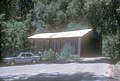
English: Oregon Creek or Freeman's Crossing Covered Bridge near Yuba City, Yuba County, California.
|
This is a category about a place or building that is listed on the National Register of Historic Places in the United States of America. Its reference number is 75000499. |
| Object location | | View all coordinates using: OpenStreetMap |
|---|
place in California listed on National Register of Historic Places  | |||||
| Upload media | |||||
| Instance of | |||||
|---|---|---|---|---|---|
| Location | Yuba County, California, Pacific States Region | ||||
| Heritage designation |
| ||||
| Inception |
| ||||
| Date of official opening |
| ||||
 | |||||
Media in category "Oregon Creek Covered Bridge"
The following 2 files are in this category, out of 2 total.
-
 OREGON CREEK C.B. YUBA CTY, CALIFORNIA.jpg 5,228 × 3,540; 4.45 MB
-
 OREGON CREEK C.B., YUBA COUNTY CALIFORNIA.jpg 5,262 × 3,564; 1.3 MB
