Category:Otham
village in Kent | |||||
| Upload media | |||||
| Instance of | |||||
|---|---|---|---|---|---|
| Location | Maidstone, Kent, South East England, England | ||||
| official website | |||||
 | |||||
Subcategories
This category has the following 7 subcategories, out of 7 total.
M
- Otham Manor (1 F)
O
- Otham War Memorial (1 F)
- Otham War Memorial Plaque (1 F)
P
- Prescott House, Otham (5 F)
S
- Stoneacre, Otham (9 F)
Media in category "Otham"
The following 128 files are in this category, out of 128 total.
-
 A very large field near Otham - geograph.org.uk - 1615347.jpg 640 × 430; 128 KB
-
 Apple orchards - geograph.org.uk - 1614320.jpg 640 × 430; 121 KB
-
 Avery Lane - geograph.org.uk - 3385035.jpg 640 × 426; 87 KB
-
 Avery Lane, Otham - geograph.org.uk - 3632650.jpg 3,488 × 2,616; 2.15 MB
-
 Barn at Green Hill, Otham - geograph.org.uk - 1418562.jpg 640 × 427; 99 KB
-
 Belks House - geograph.org.uk - 1130901.jpg 640 × 481; 113 KB
-
 Bend in the footpath - geograph.org.uk - 1615350.jpg 640 × 430; 121 KB
-
 Bungalow, Otham Street, Otham - geograph.org.uk - 1615331.jpg 640 × 430; 126 KB
-
 By the footpath to Otham - geograph.org.uk - 3392626.jpg 640 × 426; 100 KB
-
 Caring Road, near Caring - geograph.org.uk - 3632700.jpg 3,488 × 2,616; 2.21 MB
-
 Church of St Nicholas - geograph.org.uk - 3392638.jpg 640 × 426; 33 KB
-
 Church of St Nicholas, Otham - geograph.org.uk - 3392644.jpg 426 × 640; 54 KB
-
 Church of St Nicholas, Otham - geograph.org.uk - 3392649.jpg 640 × 426; 70 KB
-
 Church Road, near Otham - geograph.org.uk - 3557419.jpg 3,488 × 2,616; 3.9 MB
-
 Cobnut Avenue, Imperial Park - geograph.org.uk - 4842075.jpg 3,264 × 2,448; 1.34 MB
-
 Cottages, Stoneacre Lane, Otham - geograph.org.uk - 1614748.jpg 640 × 430; 72 KB
-
 Currant bushes in polytunnels - geograph.org.uk - 1614343.jpg 640 × 430; 135 KB
-
 Derelict farm building near Stoneacre - geograph.org.uk - 1614396.jpg 640 × 430; 124 KB
-
 Disused Building near Stoneacre - geograph.org.uk - 1281952.jpg 640 × 480; 88 KB
-
 Dry Valley east of Stoneacre Lane - geograph.org.uk - 1614741.jpg 640 × 430; 66 KB
-
 Dry Valley heading down to Stoneacre - geograph.org.uk - 1614375.jpg 640 × 430; 131 KB
-
 East Wood - geograph.org.uk - 3392613.jpg 640 × 426; 117 KB
-
 East Wood - geograph.org.uk - 3392616.jpg 640 × 426; 103 KB
-
 East Wood - geograph.org.uk - 3392621.jpg 640 × 426; 94 KB
-
 Farm building, Stoneacre Farm - geograph.org.uk - 1614390.jpg 640 × 430; 98 KB
-
 Farmland, Otham - geograph.org.uk - 3392618.jpg 640 × 426; 47 KB
-
 Field at Green Hill - geograph.org.uk - 5080185.jpg 1,600 × 1,067; 483 KB
-
 Footpath between Church Lane, Downswood and Green Hill - geograph.org.uk - 5080193.jpg 1,600 × 1,067; 763 KB
-
 Footpath from Otham - geograph.org.uk - 1615341.jpg 640 × 430; 110 KB
-
 Footpath junction in East Wood, Otham - geograph.org.uk - 1130895.jpg 640 × 481; 150 KB
-
 Footpath off Honey Lane - geograph.org.uk - 3385047.jpg 640 × 426; 95 KB
-
 Footpath signposted off Otham Lane - geograph.org.uk - 1614760.jpg 640 × 430; 71 KB
-
 Footpath to East Wood - geograph.org.uk - 1615354.jpg 640 × 430; 137 KB
-
 Footpath to Otham - geograph.org.uk - 3392605.jpg 640 × 426; 44 KB
-
 Footpath to Otham - geograph.org.uk - 3392630.jpg 640 × 426; 38 KB
-
 Footpath to St Nicholas's Church - geograph.org.uk - 1615357.jpg 640 × 430; 112 KB
-
 Footpath to Willington - geograph.org.uk - 2863284.jpg 640 × 426; 103 KB
-
 Ford at Stoneacre Farm, Otham - geograph.org.uk - 3741905.jpg 3,872 × 2,592; 4.71 MB
-
 Ford on Stoneacre Lane - geograph.org.uk - 1614729.jpg 640 × 430; 91 KB
-
 Garden in Otham, near Maidstone, Kent in southern England. - panoramio.jpg 2,272 × 1,704; 848 KB
-
 Gore Court Road, Otham - geograph.org.uk - 3586357.jpg 3,488 × 2,616; 2.16 MB
-
 Green Hill, Otham - geograph.org.uk - 3632695.jpg 3,488 × 2,616; 2.17 MB
-
 Half timbered cottage, Otham Street - geograph.org.uk - 1614746.jpg 640 × 430; 59 KB
-

-
 Heading towards Otham - geograph.org.uk - 5080172.jpg 1,600 × 1,067; 615 KB
-
 Honey Lane - geograph.org.uk - 3385043.jpg 640 × 426; 55 KB
-
 Honey Lane - geograph.org.uk - 3385046.jpg 640 × 426; 87 KB
-
 Honey Lane - geograph.org.uk - 3392586.jpg 640 × 426; 71 KB
-
 Honey Lane, Otham - geograph.org.uk - 3632652.jpg 3,488 × 2,616; 2.2 MB
-
 Honey Lane, Otham Hole - geograph.org.uk - 3392588.jpg 640 × 426; 85 KB
-
 House in Otham, near Maidstone, Kent in southern England. - panoramio.jpg 3,648 × 2,736; 4.97 MB
-
 House on Avery Lane - geograph.org.uk - 3385032.jpg 640 × 426; 56 KB
-
 House on Honey Lane - geograph.org.uk - 3385041.jpg 640 × 426; 53 KB
-
 House on Honey Lane - geograph.org.uk - 3385049.jpg 640 × 426; 71 KB
-
 Inside fruit polytunnel in Caring Farm - geograph.org.uk - 1217863.jpg 640 × 480; 120 KB
-
 Interesting village sign, Otham - geograph.org.uk - 1614752.jpg 360 × 640; 65 KB
-
 Kissing gate into Puddlets Wood - geograph.org.uk - 1217859.jpg 640 × 480; 159 KB
-
 Large field by the path from Otham - geograph.org.uk - 1615336.jpg 640 × 430; 107 KB
-
 Large field by the path from Otham - geograph.org.uk - 1615360.jpg 640 × 430; 114 KB
-
 LEAF Information Board - geograph.org.uk - 1614367.jpg 640 × 430; 147 KB
-
 Looking down Green Hill - geograph.org.uk - 3745514.jpg 4,000 × 3,000; 4.01 MB
-
 Looking towards the suburbs of Maidstone - geograph.org.uk - 1615369.jpg 640 × 430; 120 KB
-

-
 Madam Taylors Farm, Otham - geograph.org.uk - 1615334.jpg 640 × 430; 78 KB
-
 Muddy track - geograph.org.uk - 1614359.jpg 640 × 430; 127 KB
-
 New Rd, Avery Rd junction - geograph.org.uk - 3385031.jpg 640 × 426; 68 KB
-
 Northern end of East Wood - geograph.org.uk - 1615344.jpg 640 × 430; 112 KB
-
 Oak tree on the horizon - geograph.org.uk - 1614393.jpg 640 × 430; 80 KB
-
 On the Footpath between Otham and Forge Lane - geograph.org.uk - 5080160.jpg 1,600 × 1,067; 739 KB
-
 Orchard and shelterbelt - geograph.org.uk - 1614322.jpg 640 × 430; 125 KB
-
 Otham features (5) (geograph 7077691).jpg 4,320 × 3,240; 4.81 MB
-
 Otham Hole - geograph.org.uk - 3392594.jpg 640 × 426; 71 KB
-
 Otham houses (1) (geograph 7077686).jpg 4,320 × 3,240; 3.18 MB
-
 Otham houses (10) (geograph 7078462).jpg 4,319 × 3,239; 2.92 MB
-
 Otham houses (2) (geograph 7077695).jpg 4,069 × 3,051; 2.58 MB
-
 Otham houses (5) (geograph 7077790).jpg 4,320 × 3,240; 3.6 MB
-
 Otham houses (7) (geograph 7078458).jpg 4,320 × 3,240; 2.71 MB
-
 Otham houses (8) (geograph 7078459).jpg 3,870 × 2,903; 3.52 MB
-
 Otham houses (9) (geograph 7078461).jpg 4,320 × 3,240; 3.33 MB
-
 Otham Recreation Ground - geograph.org.uk - 1614756.jpg 640 × 430; 34 KB
-
 Otham Sign - geograph.org.uk - 1281953.jpg 640 × 640; 79 KB
-
 Otham Street, Otham - geograph.org.uk - 3632693.jpg 3,488 × 2,616; 2.26 MB
-
 Otham War Memorial - geograph.org.uk - 3632688.jpg 3,488 × 2,616; 2.19 MB
-
 Path heading west towards Stoneacre - geograph.org.uk - 1614317.jpg 640 × 430; 119 KB
-
 Plumpton Walk - geograph.org.uk - 1130878.jpg 481 × 640; 134 KB
-
 Pond near Stoneacre - geograph.org.uk - 2396601.jpg 1,280 × 960; 656 KB
-
 Pond near Stoneacre - geograph.org.uk - 2396614.jpg 1,280 × 960; 625 KB
-
 Pond near Stoneacre, Otham - geograph.org.uk - 3632684.jpg 3,488 × 2,616; 2.16 MB
-
 Portable tar boiler - geograph.org.uk - 134699.jpg 640 × 480; 101 KB
-
 Portable tar boiler - geograph.org.uk - 134701.jpg 480 × 640; 121 KB
-

-
 Sheep grazing in a dry valley - geograph.org.uk - 1614381.jpg 640 × 430; 112 KB
-
 Sheltered housing for OAPs - geograph.org.uk - 94910.jpg 640 × 427; 89 KB
-
 Signpost at the footpath junction - geograph.org.uk - 1615352.jpg 640 × 430; 123 KB
-
 Small Lake north of Stoneacre Lane - geograph.org.uk - 1614488.jpg 640 × 430; 89 KB
-
 Small pond by Stoneacre Lane - geograph.org.uk - 1614730.jpg 640 × 430; 87 KB
-
 Spot Farm - geograph.org.uk - 1130922.jpg 640 × 481; 74 KB
-
 Spring at Stoneacre - geograph.org.uk - 2396621.jpg 1,280 × 960; 616 KB
-
 St Nicholas's church, Otham - geograph.org.uk - 3557410.jpg 2,616 × 3,488; 2.83 MB
-
 Stile on footpath in Stoneacre Farm - geograph.org.uk - 1130914.jpg 640 × 481; 84 KB
-
 Stoneacre Farm, Otham - geograph.org.uk - 3632654.jpg 3,488 × 2,616; 2.26 MB
-
 Stoneacre Lane, Otham - geograph.org.uk - 1614737.jpg 640 × 430; 106 KB
-
 Stoneacre Lane, Otham - geograph.org.uk - 3632653.jpg 3,488 × 2,616; 2.21 MB
-
 Street in Otham, near Maidstone, Kent in southern England. - panoramio.jpg 2,272 × 1,704; 881 KB
-
 The Orchard sign - geograph.org.uk - 2176716.jpg 640 × 480; 44 KB
-
 The Orchard Spot, Otham - geograph.org.uk - 3557424.jpg 3,041 × 1,747; 2 MB
-
 The White Horse Pub, Otham - geograph.org.uk - 1130890.jpg 640 × 481; 73 KB
-
 The White Horse sign - geograph.org.uk - 2176631.jpg 480 × 640; 76 KB
-
 The White Horse, Otham - geograph.org.uk - 2176630.jpg 640 × 480; 80 KB
-
 The White Horse, Otham - geograph.org.uk - 3586355.jpg 3,488 × 2,616; 2.21 MB
-
 Tracks in the wheat - geograph.org.uk - 3043476.jpg 640 × 480; 117 KB
-
 Tractor tracks in the wheat - geograph.org.uk - 3043494.jpg 640 × 480; 158 KB
-
 View from Green Hill - geograph.org.uk - 3745518.jpg 4,000 × 3,000; 4.07 MB
-
 View from Otham Lane - geograph.org.uk - 3745528.jpg 4,000 × 3,000; 4.01 MB
-
 View south from Stoneacre Lane - geograph.org.uk - 1614731.jpg 640 × 430; 101 KB
-
 War Memorial, Otham - geograph.org.uk - 1614743.jpg 640 × 430; 51 KB
-
 Wardes Bungalow, Otham - geograph.org.uk - 1615340.jpg 640 × 430; 131 KB
-
 Weatherboarding, Honey Lane - geograph.org.uk - 3392581.jpg 640 × 426; 66 KB
-
 White Horse Lane, Otham - geograph.org.uk - 3586352.jpg 3,488 × 2,616; 2.17 MB
-
 Country Park sign on North Downs - geograph.org.uk - 414446.jpg 640 × 427; 60 KB
-

-
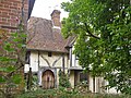
 House next to Otham Church, Kent - geograph.org.uk - 325329.jpg 640 × 369; 115 KB
-

-

-
 Roadside mushrooms - geograph.org.uk - 80395.jpg 447 × 640; 153 KB
-

-
 Tudor Park golf course - geograph.org.uk - 79914.jpg 640 × 480; 123 KB
-
 Village sign, Otham - geograph.org.uk - 80485.jpg 640 × 532; 79 KB


_(geograph_7077691).jpg)

_(geograph_7077686).jpg)
_(geograph_7078462).jpg)
_(geograph_7077695).jpg)
_(geograph_7077790).jpg)
_(geograph_7078458).jpg)
_(geograph_7078459).jpg)
_(geograph_7078461).jpg)


