Category:Ottilienkapelle (Amendingen)
| Object location | | View all coordinates using: OpenStreetMap |
|---|
This is the category of the Bavarian Baudenkmal (cultural heritage monument) with the ID D-7-64-000-277 (Wikidata)
|
building in Memmingen, Swabia, Germany  | |||||
| Upload media | |||||
| Instance of | |||||
|---|---|---|---|---|---|
| Location | Memmingen, Swabia, Bavaria, Germany | ||||
| Street address |
| ||||
| Heritage designation | |||||
 | |||||
Media in category "Ottilienkapelle (Amendingen)"
The following 6 files are in this category, out of 6 total.
-
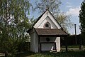
 AmendingenOttilienkapelle.jpg 653 × 951; 233 KB
-
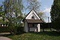
 AmendingenOttilienkapelleKreuz.jpg 2,848 × 4,272; 6.71 MB
-
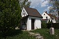
 AmendingenOttilienkapelleKreuz1.jpg 4,272 × 2,848; 6.19 MB
-
 AmendingenOttilienkapelleKreuz2.jpg 4,272 × 2,848; 6.64 MB
-
 AmendingenOttilienkapelleKreuz3.jpg 4,272 × 2,848; 5.87 MB
-
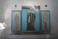 AmendingenOttilienkapelleKreuzInnen.jpg 4,272 × 2,848; 4.66 MB


