Category:Oud-Amelisweerd
| Object location | | View all coordinates using: OpenStreetMap |
|---|
 | |||||
| Upload media | |||||
| Instance of | |||||
|---|---|---|---|---|---|
| Location | Bunnik, Utrecht, Netherlands | ||||
| Has part(s) | |||||
| Heritage designation |
| ||||
 | |||||
|
This is a category about rijksmonumentcomplex number 526327
|
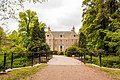
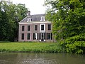
Hoofdgebouw:
|
This is a category about rijksmonument number 526328
|
Historische tuin- en parkaanleg:
|
This is a category about rijksmonument number 526329
|
Koetshuis:
|
This is a category about rijksmonument number 526330
|
IJskelder:
|
This is a category about rijksmonument number 526331
|
Brug:
|
This is a category about rijksmonument number 526332
|
Boerderij ensemble 'De zonnewijzer': dwarshuisboerderij
|
This is a category about rijksmonument number 526333
|
Boerderij ensemble 'De zonnewijzer': zomerhuis
|
This is a category about rijksmonument number 526334
|
Boerderij ensemble 'De zonnewijzer': kapberg
|
This is a category about rijksmonument number 526335
|
Boerderij ensemble 'De zonnewijzer': schuur
|
This is a category about rijksmonument number 526345
|
Boerderij ensemble 'De Knapschinkel': dwarshuisboerderij
|
This is a category about rijksmonument number 526346
|
Dubbele garage:
|
This is a category about rijksmonument number 526347
|
Boerderij ensemble "De Knapschinkel": bedrijfsgedeelte
|
This is a category about rijksmonument number 529969
|
| Address |
|
Subcategories
This category has the following 2 subcategories, out of 2 total.
D
- De Zonnewijzer, Bunnik (26 F)
M
Media in category "Oud-Amelisweerd"
The following 106 files are in this category, out of 106 total.
-
 3981 Bunnik, Netherlands - panoramio (5).jpg 2,048 × 1,148; 917 KB
-
 3981 Bunnik, Netherlands - panoramio (6).jpg 2,048 × 1,148; 563 KB
-
 3981 Bunnik, Netherlands - panoramio (63).jpg 4,896 × 3,264; 3.85 MB
-
 3981 Bunnik, Netherlands - panoramio (71).jpg 4,896 × 3,264; 3.24 MB
-
 3981 Bunnik, Netherlands - panoramio (75).jpg 4,896 × 3,264; 2.58 MB
-
 3981 Bunnik, Netherlands - panoramio (91).jpg 2,048 × 1,366; 807 KB
-
 526328 Oud Amelisweerd Bunnik Utrecht-002 Hoofdgebouw.jpg 4,138 × 2,759; 5.82 MB
-
 526328 Oud Amelisweerd Bunnik Utrecht-006 Hoofdgebouw.jpg 4,141 × 2,761; 7.73 MB
-
 526328 Oud Amelisweerd Bunnik Utrecht-009 Hoofdgebouw.jpg 4,024 × 2,683; 7.04 MB
-
 526328 Oud Amelisweerd Bunnik Utrecht-010 Hoofdgebouw.jpg 4,272 × 2,848; 7.28 MB
-
 526329 Oud Amelisweerd Bunnik Utrecht-004 Park.jpg 4,272 × 2,848; 9.9 MB
-
 526329 Oud Amelisweerd Bunnik Utrecht-012 Park.jpg 4,252 × 2,835; 8.47 MB
-
 526329 Oud Amelisweerd Bunnik Utrecht-013 Park.jpg 4,126 × 2,751; 7.89 MB
-
 526330 Oud Amelisweerd Bunnik Utrecht-001 Koetshuis.jpg 4,272 × 2,848; 4.22 MB
-
 526330 Oud Amelisweerd Bunnik Utrecht-011 Koetshuis.jpg 2,848 × 4,272; 7.69 MB
-
 526331 Oud Amelisweerd Bunnik Utrecht-007 Ijskelder.jpg 4,272 × 2,848; 9.73 MB
-
 526331 Oud Amelisweerd Bunnik Utrecht-008 Ijskelder.jpg 2,848 × 4,272; 5.79 MB
-
 526332 Oud Amelisweerd Bunnik Utrecht-005 Brug.jpg 4,223 × 2,815; 7.14 MB
-
 526335 Oud Amelisweerd Bunnik Utrecht-003 Kapberg.jpg 4,194 × 2,796; 5.11 MB
-
 Amelisweerd 01.JPG 4,608 × 3,456; 7 MB
-
 Amelisweerd 02.JPG 4,608 × 3,456; 7.38 MB
-
 Amelisweerd 03.JPG 4,608 × 3,456; 6.83 MB
-
 Amelisweerd 04.JPG 4,608 × 3,456; 7 MB
-
 Amelisweerd 08.JPG 4,608 × 3,456; 7.15 MB
-
 Amelisweerd 10.JPG 4,608 × 3,456; 7.82 MB
-
 Amelisweerd A27 verbreding protest 2013.jpg 4,752 × 3,168; 7.14 MB
-
 Bunnik Heerlijkheden.png 1,567 × 1,382; 559 KB
-
 Bunnik-bij Oud-Amelisweerd.jpg 4,032 × 2,268; 4.09 MB
-
 Exterieur RECHTER ZIJGEVEL, RAAM - Bunnik - 20311761 - RCE.jpg 1,192 × 1,200; 496 KB
-

-

-

-
 HUA-201056-Gezicht op het middeleeuwse huis Oud Amelisweerd tussen Utrecht en Bunnik.jpg 2,087 × 1,474; 537 KB
-

-

-

-

-

-

-

-

-
 INT. BEGANE GROND, LIFT, DICHTE DEUR - Bunnik - 20308540 - RCE.jpg 1,195 × 1,200; 254 KB
-
 INT. BEGANE GROND, LIFT, OPEN DEUR - Bunnik - 20308541 - RCE.jpg 1,195 × 1,200; 242 KB
-
 INT. HIJSINSTALLATIE, DETAIL - Bunnik - 20308545 - RCE.jpg 1,188 × 1,200; 221 KB
-
 INT. LIFT - Bunnik - 20308542 - RCE.jpg 1,183 × 1,200; 216 KB
-
 INT. LIFT - Bunnik - 20308543 - RCE.jpg 1,188 × 1,200; 202 KB
-
 INT. LIFT - Bunnik - 20308544 - RCE.jpg 1,181 × 1,200; 256 KB
-
 INT. OVERZICHT KAMER - Bunnik - 20308537 - RCE.jpg 1,195 × 1,200; 263 KB
-
 INT. OVERZICHT KAMER - Bunnik - 20308538 - RCE.jpg 1,183 × 1,200; 312 KB
-
 INT. OVERZICHT KAMER - Bunnik - 20308539 - RCE.jpg 1,181 × 1,200; 255 KB
-
 INT. ZOLDER, HIJSMECHANISME - Bunnik - 20308548 - RCE.jpg 1,200 × 1,200; 227 KB
-
 INT. ZOLDER, HIJSMECHANISME - Bunnik - 20308549 - RCE.jpg 1,192 × 1,200; 237 KB
-
 INT. ZOLDER, HIJSMECHANISME - Bunnik - 20308550 - RCE.jpg 1,192 × 1,200; 251 KB
-
 INT. ZOLDER, HIJSMECHANISME - Bunnik - 20308551 - RCE.jpg 1,181 × 1,200; 222 KB
-
 INT. ZOLDER, HIJSWIEL - Bunnik - 20308546 - RCE.jpg 1,192 × 1,200; 261 KB
-
 INT. ZOLDER, HIJSWIEL - Bunnik - 20308547 - RCE.jpg 1,178 × 1,200; 259 KB
-
 INTERIEUR, BENEDEN KAMER, PAPIERBEHANGSEL, LINNENBEHANGSEL - Bunnik - 20269696 - RCE.jpg 1,185 × 1,200; 304 KB
-
 INTERIEUR, BENEDEN KAMER, PAPIERBEHANGSEL, LINNENBEHANGSEL - Bunnik - 20269698 - RCE.jpg 1,189 × 1,200; 227 KB
-
 INTERIEUR, BENEDEN KAMER, PAPIERBEHANGSEL, LINNENBEHANGSEL - Bunnik - 20269701 - RCE.jpg 1,192 × 1,200; 286 KB
-
 INTERIEUR, BENEDEN KAMER, PAPIERBEHANGSEL, LINNENBEHANGSEL - Bunnik - 20269703 - RCE.jpg 1,191 × 1,200; 223 KB
-
 INTERIEUR, BENEDEN KAMER, PAPIERBEHANGSEL, LINNENBEHANGSEL - Bunnik - 20269706 - RCE.jpg 1,189 × 1,200; 301 KB
-
 INTERIEUR, BENEDEN KAMER, PAPIERBEHANGSEL, LINNENBEHANGSEL - Bunnik - 20269709 - RCE.jpg 1,193 × 1,200; 335 KB
-
 INTERIEUR, BENEDEN KAMER, PAPIERBEHANGSEL, LINNENBEHANGSEL - Bunnik - 20269711 - RCE.jpg 1,190 × 1,200; 251 KB
-
 INTERIEUR, BENEDEN KAMER, PAPIERBEHANGSEL, LINNENBEHANGSEL - Bunnik - 20269713 - RCE.jpg 1,192 × 1,200; 328 KB
-
 INTERIEUR, BENEDEN KAMER, PAPIERBEHANGSEL, LINNENBEHANGSEL - Bunnik - 20269714 - RCE.jpg 1,193 × 1,200; 337 KB
-
 INTERIEUR, BENEDEN KAMER, PAPIERBEHANGSEL, LINNENBEHANGSEL - Bunnik - 20269716 - RCE.jpg 1,188 × 1,200; 219 KB
-
 INTERIEUR, BENEDEN KAMER, PAPIERBEHANGSEL, LINNENBEHANGSEL - Bunnik - 20269717 - RCE.jpg 1,186 × 1,200; 267 KB
-
 INTERIEUR, BENEDEN KAMER, PAPIERBEHANGSEL, LINNENBEHANGSEL - Bunnik - 20269719 - RCE.jpg 1,195 × 1,200; 253 KB
-
 INTERIEUR, BENEDEN KAMER, PAPIERBEHANGSEL, LINNENBEHANGSEL - Bunnik - 20269720 - RCE.jpg 1,188 × 1,200; 299 KB
-
 INTERIEUR, BENEDEN KAMER, PAPIERBEHANGSEL, LINNENBEHANGSEL - Bunnik - 20269722 - RCE.jpg 1,188 × 1,200; 299 KB
-

-

-

-

-

-

-

-

-

-

-

-

-

-

-

-
 INTERIEUR, BENEDEN VERDIEPING, ACHTERKAMER, BEHANGSEL - Bunnik - 20270627 - RCE.jpg 1,193 × 1,200; 256 KB
-
 INTERIEUR, BENEDEN VERDIEPING, ACHTERKAMER, BEHANGSEL - Bunnik - 20270628 - RCE.jpg 1,191 × 1,200; 263 KB
-
 INTERIEUR, BENEDEN VERDIEPING, TUSSENKAMER, BEHANGSEL - Bunnik - 20270629 - RCE.jpg 1,185 × 1,200; 250 KB
-
 INTERIEUR, BENEDEN VERDIEPING, TUSSENKAMER, BEHANGSEL - Bunnik - 20270630 - RCE.jpg 1,187 × 1,200; 261 KB
-
 Kasteel Ameliswaard, 1807 Ameliswaard (titel op object), RP-P-OB-86.959.jpg 4,644 × 4,745; 3.16 MB
-
 Koetshuis - Bunnik - 20045055 - RCE.jpg 1,200 × 802; 168 KB
-
 Landgoed Oud-Amelisweerd.jpg 1,424 × 1,068; 507 KB
-
 Landhuis Oud Amelisweerd klein.jpg 3,072 × 2,304; 3.84 MB
-
 Oud Amelisweerd brug.jpg 2,154 × 1,476; 762 KB
-
 Oud Amelisweerd Bunnik.jpg 1,536 × 1,047; 392 KB
-
 Oud Amelisweerd front groot.jpg 1,000 × 664; 209 KB
-
 Oud Amelisweerd koetshuis.jpg 2,136 × 1,476; 575 KB
-
 Oud Amelisweerd tuin.jpg 2,148 × 1,470; 761 KB
-
 Oud Amelisweerd.jpg 985 × 633; 124 KB
-
 Oud-Amelisweerd 2012-09-04 14-42-28.jpg 2,592 × 1,944; 2.27 MB
-
 OudAmelisweerd.jpg 890 × 663; 212 KB
-

-
 Voor- en zijgevel nr. 772-11 - Bunnik - 20470337 - RCE.jpg 1,200 × 900; 188 KB
-
 Vooraanzicht - Bloemendaal - 20036190 - RCE.jpg 1,200 × 808; 277 KB
-
 Voorgevel van het huis - Bunnik - 20045054 - RCE.jpg 1,200 × 803; 171 KB
-
 Zij- en voorgevel ROVU, Utrecht nr. II-35 - Bunnik - 20470336 - RCE.jpg 1,200 × 900; 137 KB
.jpg)
.jpg)
.jpg)
.jpg)
.jpg)
.jpg)


,_RP-P-AO-5-109-1.jpg)


,_RP-P-OB-86.959.jpg)


_Amelisweerd,_so_als_het_zig_vertoonde_in_%27t_jaar_1672,_toen_genoemd_Groenewoude_(titel_op_object),_RP-P-AO-5-109-2.jpg)


