Category:Oudegracht 8, Utrecht
| Object location | | View all coordinates using: OpenStreetMap |
|---|
 | |||||
| Upload media | |||||
| Instance of |
| ||||
|---|---|---|---|---|---|
| Location | Utrecht, Netherlands | ||||
| Street address |
| ||||
| Located on street | |||||
| Heritage designation |
| ||||
 | |||||
|
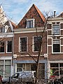
This is a category about rijksmonument number 36593
|
| Address |
|
Media in category "Oudegracht 8, Utrecht"
The following 4 files are in this category, out of 4 total.
-
 Exterieur OVERZICHT - Utrecht - 20305925 - RCE.jpg 1,200 × 788; 245 KB
-
 Exterieur OVERZICHT VOORGEVELS - Utrecht - 20305926 - RCE.jpg 1,200 × 788; 215 KB
-
 Oudegracht 8 Utrecht.jpg 2,268 × 3,024; 2.2 MB
-
 Voorgevels - Utrecht - 20236435 - RCE.jpg 803 × 1,200; 189 KB


