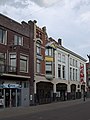
Category:Oudestraat 33, Kampen
| Object location | | View all coordinates using: OpenStreetMap |
|---|
 | |||||
| Upload media | |||||
| Instance of |
| ||||
|---|---|---|---|---|---|
| Location | Kampen, Overijssel, Netherlands | ||||
| Heritage designation |
| ||||
 | |||||
|
This is a category about rijksmonument number 23075
|
| Address |
|
Media in category "Oudestraat 33, Kampen"
The following 4 files are in this category, out of 4 total.
-
 Kampen Oudestraat33.jpg 2,736 × 3,648; 4.95 MB
-
 Kampen Oudestraat35.jpg 2,736 × 3,648; 5.15 MB
-
 Voorgevels - Kampen - 20123290 - RCE.jpg 1,200 × 810; 198 KB
-
 W.l - Kampen - 20123287 - RCE.jpg 881 × 1,200; 206 KB


