Category:Ouvrage du Galgenberg
| Object location | | View all coordinates using: OpenStreetMap |
|---|
Ouvrage of the Maginot Line  | |||||
| Upload media | |||||
| Instance of | |||||
|---|---|---|---|---|---|
| Location | Cattenom, canton of Cattenom | ||||
 | |||||
Subcategories
This category has only the following subcategory.
O
Media in category "Ouvrage du Galgenberg"
The following 136 files are in this category, out of 136 total.
-
 A15 devant le magasin aux artifices vers M1.jpg 3,531 × 2,576; 1.24 MB
-
 A15 Galgenberg EM.jpg 2,592 × 1,944; 986 KB
-
 A15 tourelle mitrailleuse double.jpg 4,592 × 2,576; 1.05 MB
-
 Base d'une coupole escamotable armée de 81.jpg 4,592 × 2,576; 2.28 MB
-
 Cage d'ascenceur et escalier.jpg 2,576 × 4,592; 1.06 MB
-
 Cattenom depuis le Galgenberg.jpg 2,000 × 1,074; 224 KB
-
 Cuisine de la troupe.jpg 4,592 × 2,576; 450 KB
-
 Double porte blindée vers le bloc 3.jpg 2,576 × 4,592; 583 KB
-
 Décoration d'intérieur du PC 2.jpg 2,039 × 1,379; 461 KB
-
 Décoration d'intérieur du PC 3.jpg 1,158 × 612; 165 KB
-
 Décoration d'intérieur du PC.jpg 1,663 × 763; 209 KB
-
 Décoration d'intérieur.jpg 2,231 × 1,355; 522 KB
-
 EM porte blindée lumière du jour porte du poste.jpg 4,592 × 2,576; 464 KB
-
 EM quai de déchargement.jpg 4,592 × 2,576; 655 KB
-
 EM rails du canon de 25 FM et lance grenade meutrières.jpg 4,592 × 2,576; 373 KB
-
 EM rails meutrières.jpg 4,592 × 2,576; 436 KB
-
 Entrée de l'usine.jpg 4,578 × 2,453; 473 KB
-
 Entrée des hommes Galgenberg alimentation electrique coupole.jpg 3,822 × 2,748; 655 KB
-
 Espace d'hygiène corporelle de la troupe.jpg 2,576 × 4,592; 745 KB
-
 Foyer du soldat.jpg 4,592 × 2,576; 402 KB
-
 Galgenberg salle d'opération.jpg 4,592 × 2,576; 364 KB
-
 Go-galgenberg-b6-2001-05.jpg 955 × 603; 305 KB
-
 Gros Ouvrage du Galgenberg (14880040139).jpg 3,648 × 2,736; 7.25 MB
-
 Gros Ouvrage du Galgenberg (14880042169).jpg 3,648 × 2,736; 6.68 MB
-
 Gros Ouvrage du Galgenberg (14880044359).jpg 3,648 × 2,736; 6.74 MB
-
 Gros Ouvrage du Galgenberg (14880067819).jpg 3,648 × 2,736; 7.01 MB
-
 Gros Ouvrage du Galgenberg (14880070069).jpg 3,648 × 2,736; 6.49 MB
-
 Gros Ouvrage du Galgenberg (14880091210).jpg 3,648 × 2,736; 6.48 MB
-
 Gros Ouvrage du Galgenberg (14880095209).jpg 3,648 × 2,736; 6.49 MB
-
 Gros Ouvrage du Galgenberg (14880105640).jpg 3,648 × 2,736; 7.03 MB
-
 Gros Ouvrage du Galgenberg (14880126540).jpg 3,648 × 2,736; 7.07 MB
-
 Gros Ouvrage du Galgenberg (14880133510).jpg 3,648 × 2,736; 7.02 MB
-
 Gros Ouvrage du Galgenberg (14880146928).jpg 2,736 × 3,648; 5.67 MB
-
 Gros Ouvrage du Galgenberg (14880151840).jpg 3,648 × 2,736; 5.68 MB
-
 Gros Ouvrage du Galgenberg (14880169570).jpg 3,648 × 2,736; 6.55 MB
-
 Gros Ouvrage du Galgenberg (14880189460).jpg 3,648 × 2,736; 6.5 MB
-
 Gros Ouvrage du Galgenberg (14880191770).jpg 2,736 × 3,648; 6.4 MB
-
 Gros Ouvrage du Galgenberg (14880197287).jpg 2,736 × 3,648; 6.79 MB
-
 Gros Ouvrage du Galgenberg (14880198528).jpg 3,648 × 2,736; 7.33 MB
-
 Gros Ouvrage du Galgenberg (14880202340).jpg 2,736 × 3,648; 6.83 MB
-
 Gros Ouvrage du Galgenberg (14880203248).jpg 3,648 × 2,736; 6.46 MB
-
 Gros Ouvrage du Galgenberg (14880203377).jpg 3,648 × 2,736; 7.2 MB
-
 Gros Ouvrage du Galgenberg (14880223108).jpg 3,648 × 2,736; 6.41 MB
-
 Gros Ouvrage du Galgenberg (14880226998).jpg 3,648 × 2,736; 6.36 MB
-
 Gros Ouvrage du Galgenberg (14880233618).jpg 3,648 × 2,736; 6.83 MB
-
 Gros Ouvrage du Galgenberg (14880243078).jpg 3,648 × 2,736; 6.91 MB
-
 Gros Ouvrage du Galgenberg (14880248477).jpg 3,648 × 2,736; 7.02 MB
-
 Gros Ouvrage du Galgenberg (14880257197).jpg 3,648 × 2,736; 6.07 MB
-
 Gros Ouvrage du Galgenberg (14880257498).jpg 3,648 × 2,736; 6.44 MB
-
 Gros Ouvrage du Galgenberg (14880266048).jpg 3,648 × 2,736; 7.22 MB
-
 Gros Ouvrage du Galgenberg (14880276687).jpg 3,648 × 2,736; 6.42 MB
-
 Gros Ouvrage du Galgenberg (14880282917).jpg 3,648 × 2,736; 6.91 MB
-
 Gros Ouvrage du Galgenberg (14880294717).jpg 2,736 × 3,648; 5.39 MB
-
 Gros Ouvrage du Galgenberg (15043749946).jpg 3,648 × 2,736; 5.03 MB
-
 Gros Ouvrage du Galgenberg (15043751796).jpg 3,648 × 2,736; 5.03 MB
-
 Gros Ouvrage du Galgenberg (15043759146).jpg 3,648 × 2,736; 6.61 MB
-
 Gros Ouvrage du Galgenberg (15043761336).jpg 3,648 × 2,736; 6.49 MB
-
 Gros Ouvrage du Galgenberg (15043788856).jpg 3,648 × 2,736; 6.47 MB
-
 Gros Ouvrage du Galgenberg (15043797636).jpg 3,648 × 2,736; 7.39 MB
-
 Gros Ouvrage du Galgenberg (15043815066).jpg 3,648 × 2,736; 6.93 MB
-
 Gros Ouvrage du Galgenberg (15043825806).jpg 3,648 × 2,736; 6.09 MB
-
 Gros Ouvrage du Galgenberg (15063716061).jpg 2,736 × 3,648; 6.11 MB
-
 Gros Ouvrage du Galgenberg (15063770181).jpg 3,648 × 2,736; 6.4 MB
-
 Gros Ouvrage du Galgenberg (15063779081).jpg 2,736 × 3,648; 6.4 MB
-
 Gros Ouvrage du Galgenberg (15066375192).jpg 3,648 × 2,736; 5.64 MB
-
 Gros Ouvrage du Galgenberg (15066391162).jpg 2,736 × 3,648; 6.7 MB
-
 Gros Ouvrage du Galgenberg (15066402762).jpg 3,648 × 2,736; 6.48 MB
-
 Gros Ouvrage du Galgenberg (15066431162).jpg 2,736 × 3,648; 6.09 MB
-
 Gros Ouvrage du Galgenberg (15066485142).jpg 3,648 × 2,736; 6.28 MB
-
 Gros Ouvrage du Galgenberg (15066487262).jpg 3,648 × 2,736; 6.52 MB
-
 Gros Ouvrage du Galgenberg (15066734615).jpg 3,648 × 2,736; 6.35 MB
-
 Gros Ouvrage du Galgenberg (15066738335).jpg 2,736 × 3,648; 5.82 MB
-
 Gros Ouvrage du Galgenberg (15066821045).jpg 3,648 × 2,736; 6.82 MB
-
 Gros Ouvrage du Galgenberg (9607909021).jpg 3,648 × 2,736; 6.65 MB
-
 Gros Ouvrage du Galgenberg (9607910903).jpg 3,648 × 2,736; 7.07 MB
-
 Gros Ouvrage du Galgenberg (9607912761).jpg 3,648 × 2,736; 7.31 MB
-
 Gros Ouvrage du Galgenberg (9607914685).jpg 3,648 × 2,736; 7.32 MB
-
 Gros Ouvrage du Galgenberg (9607916571).jpg 3,648 × 2,736; 7.08 MB
-
 Gros Ouvrage du Galgenberg (9607924415).jpg 3,648 × 2,736; 7.08 MB
-
 Gros Ouvrage du Galgenberg (9607926307).jpg 3,648 × 2,736; 6.81 MB
-
 Gros Ouvrage du Galgenberg (9607928069).jpg 3,648 × 2,736; 6.16 MB
-
 Gros Ouvrage du Galgenberg (9607931281).jpg 3,648 × 2,736; 5.65 MB
-
 Gros Ouvrage du Galgenberg (9607932821).jpg 3,648 × 2,736; 5.52 MB
-
 Gros Ouvrage du Galgenberg (9607934453).jpg 3,648 × 2,736; 6 MB
-
 Gros Ouvrage du Galgenberg (9607935911).jpg 3,648 × 2,736; 5.77 MB
-
 Gros Ouvrage du Galgenberg (9607939337).jpg 3,648 × 2,736; 6.29 MB
-
 Gros Ouvrage du Galgenberg (9607942553).jpg 3,648 × 2,736; 6.03 MB
-
 Gros Ouvrage du Galgenberg (9607944257).jpg 3,648 × 2,736; 6.25 MB
-
 Gros Ouvrage du Galgenberg (9607949373).jpg 3,648 × 2,736; 5.69 MB
-
 Gros Ouvrage du Galgenberg (9607952553).jpg 3,648 × 2,736; 5.87 MB
-
 Gros Ouvrage du Galgenberg (9607962587).jpg 3,648 × 2,736; 6.32 MB
-
 Gros Ouvrage du Galgenberg (9607967343).jpg 3,648 × 2,736; 5.8 MB
-
 Gros Ouvrage du Galgenberg (9607968931).jpg 3,648 × 2,736; 6.51 MB
-
 Gros Ouvrage du Galgenberg (9607970505).jpg 3,648 × 2,736; 6.48 MB
-
 Gros Ouvrage du Galgenberg (9607973429).jpg 3,648 × 2,736; 5.82 MB
-
 Gros Ouvrage du Galgenberg (9607974953).jpg 3,648 × 2,736; 5.81 MB
-
 Gros Ouvrage du Galgenberg (9607976531).jpg 3,648 × 2,736; 5.9 MB
-
 Gros Ouvrage du Galgenberg (9607979455).jpg 3,648 × 2,736; 5.24 MB
-
 Gros Ouvrage du Galgenberg (9607982515).jpg 3,648 × 2,736; 5.25 MB
-
 Gros Ouvrage du Galgenberg (9607993741).jpg 3,648 × 2,736; 7.19 MB
-
 Gros Ouvrage du Galgenberg (9611152808).jpg 3,648 × 2,736; 6.62 MB
-
 Gros Ouvrage du Galgenberg (9611154768).jpg 3,648 × 2,736; 6.91 MB
-
 Gros Ouvrage du Galgenberg (9611156788).jpg 3,648 × 2,736; 7 MB
-
 Gros Ouvrage du Galgenberg (9611164054).jpg 3,648 × 2,736; 5.92 MB
-
 Gros Ouvrage du Galgenberg (9611172152).jpg 3,648 × 2,736; 6.04 MB
-
 Gros Ouvrage du Galgenberg (9611175630).jpg 3,648 × 2,736; 5.83 MB
-
 Gros Ouvrage du Galgenberg (9611180756).jpg 3,648 × 2,736; 6.17 MB
-
 Gros Ouvrage du Galgenberg (9611182500).jpg 3,648 × 2,736; 6.37 MB
-
 Gros Ouvrage du Galgenberg (9611185772).jpg 3,648 × 2,736; 6.2 MB
-
 Gros Ouvrage du Galgenberg (9611189382).jpg 3,648 × 2,736; 6.77 MB
-
 Gros Ouvrage du Galgenberg (9611190872).jpg 3,648 × 2,736; 5.43 MB
-
 Gros Ouvrage du Galgenberg (9611192700).jpg 3,648 × 2,736; 6.73 MB
-
 Gros Ouvrage du Galgenberg (9611194462).jpg 3,648 × 2,736; 6.59 MB
-
 Gros Ouvrage du Galgenberg (9611199138).jpg 3,648 × 2,736; 6.36 MB
-
 Gros Ouvrage du Galgenberg (9611200656).jpg 3,648 × 2,736; 6.02 MB
-
 Gros Ouvrage du Galgenberg (9611206932).jpg 3,648 × 2,736; 6.08 MB
-
 Gros Ouvrage du Galgenberg (9611212986).jpg 3,648 × 2,736; 5.53 MB
-
 Gros Ouvrage du Galgenberg (9611215978).jpg 3,648 × 2,736; 5.54 MB
-
 Gros Ouvrage du Galgenberg (9611219366).jpg 3,648 × 2,736; 6.84 MB
-
 Gros Ouvrage du Galgenberg (9611220960).jpg 3,648 × 2,736; 5.61 MB
-
 Gros Ouvrage du Galgenberg (9611222830).jpg 3,648 × 2,736; 6.21 MB
-
 Gros Ouvrage du Galgenberg (9611224652).jpg 3,648 × 2,736; 6.33 MB
-
 Gros Ouvrage du Galgenberg (9611226460).jpg 3,648 × 2,736; 6.32 MB
-
 Générateur auxilière d'électricité.jpg 2,576 × 4,592; 640 KB
-
 Latrines des casernes.jpg 2,576 × 4,592; 696 KB
-
 Maçonnerie de A15.jpg 2,576 × 4,592; 708 KB
-
 Meurtrière de l'EM.jpg 4,592 × 2,576; 350 KB
-
 Mitrailleuse double de EM.jpg 4,592 × 2,576; 500 KB
-
 Ouvrage Galgenberg carte.png 964 × 569; 54 KB
-
 P7207125 (9611195892).jpg 3,648 × 2,736; 5.94 MB
-
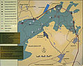
 Plan du fort.jpg 3,061 × 2,571; 683 KB
-
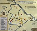
 Plan-secteur-bois-de-Cattenom.jpg 3,074 × 2,435; 1.42 MB
-
 Porte anti-déflagration.jpg 2,480 × 3,840; 1.29 MB
-
 Réseau de barbelés sur queue de cochon.jpg 4,592 × 2,576; 1.1 MB
-
 Salle 49 cuisine de la troupe.jpg 4,592 × 2,576; 669 KB
-
 Salle à manger de la troupe.jpg 2,663 × 3,005; 494 KB


.jpg)
.jpg)
.jpg)
.jpg)
.jpg)
.jpg)
.jpg)
.jpg)
.jpg)
.jpg)
.jpg)
.jpg)
.jpg)
.jpg)
.jpg)
.jpg)
.jpg)
.jpg)
.jpg)
.jpg)
.jpg)
.jpg)
.jpg)
.jpg)
.jpg)
.jpg)
.jpg)
.jpg)
.jpg)
.jpg)
.jpg)
.jpg)
.jpg)
.jpg)
.jpg)
.jpg)
.jpg)
.jpg)
.jpg)
.jpg)
.jpg)
.jpg)
.jpg)
.jpg)
.jpg)
.jpg)
.jpg)
.jpg)
.jpg)
.jpg)
.jpg)
.jpg)
.jpg)
.jpg)
.jpg)
.jpg)
.jpg)
.jpg)
.jpg)
.jpg)
.jpg)
.jpg)
.jpg)
.jpg)
.jpg)
.jpg)
.jpg)
.jpg)
.jpg)
.jpg)
.jpg)
.jpg)
.jpg)
.jpg)
.jpg)
.jpg)
.jpg)
.jpg)
.jpg)
.jpg)
.jpg)
.jpg)
.jpg)
.jpg)
.jpg)
.jpg)
.jpg)
.jpg)
.jpg)
.jpg)
.jpg)
.jpg)
.jpg)
.jpg)
.jpg)
.jpg)
.jpg)
.jpg)
.jpg)
.jpg)
.jpg)


.jpg)


