Category:Pabbay, Barra Isles
island in Barra Isles, Scotland, United Kingdom  | |||||
| Upload media | |||||
| Pronunciation audio | |||||
|---|---|---|---|---|---|
| Instance of | |||||
| Part of |
| ||||
| Location | Outer Hebrides, Scotland | ||||
| Located in or next to body of water |
| ||||
| Owned by | |||||
| Operator | |||||
| official website | |||||
 | |||||
Pabbay (Scottish Gaelic: Pabaigh) is one of the Barra Isles at the southern tip of the Outer Hebrides of Scotland.
Media in category "Pabbay, Barra Isles"
The following 15 files are in this category, out of 15 total.
-
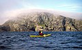 Crossing to Pabby - geograph.org.uk - 1496920.jpg 640 × 390; 87 KB
-
 Early morning - geograph.org.uk - 1496933.jpg 640 × 480; 60 KB
-
 Flodday - geograph.org.uk - 83696.jpg 640 × 428; 42 KB
-
 Heisgeir A-Muigh - geograph.org.uk - 2062219.jpg 3,264 × 2,448; 1.32 MB
-
 Heisgeir A-Staigh - geograph.org.uk - 3536528.jpg 1,024 × 682; 66 KB
-
 Hesgeir a Staigh - geograph.org.uk - 2062208.jpg 2,388 × 1,632; 691 KB
-
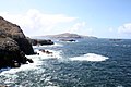 Looking south to Mingulay - geograph.org.uk - 826421.jpg 640 × 426; 69 KB
-
 Outer Heisker - geograph.org.uk - 2062229.jpg 3,264 × 2,448; 1.35 MB
-
 Pabbay stone.png 920 × 1,100; 937 KB
-
 Ruined Building on Pabbay, Outer Hebrides - geograph.org.uk - 91358.jpg 445 × 640; 103 KB
-
 Seals off Pabby - geograph.org.uk - 1496872.jpg 640 × 568; 124 KB
-
 South from Vatersay to Sundray, Pabbay, Mingulay - panoramio.jpg 3,008 × 2,000; 2.63 MB
-
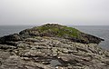 The Fort of Dunan Ruadh - geograph.org.uk - 615538.jpg 640 × 406; 85 KB
-
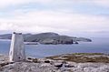 The Hoe, Pabbay, Outer Hebrides - geograph.org.uk - 206295.jpg 640 × 419; 50 KB
-
 Theisgeir a-muigh - geograph.org.uk - 3536531.jpg 1,024 × 682; 90 KB


