Category:Pahvant Butte
butte in Millard County, Utah, United States  | |||||
| Upload media | |||||
| Instance of | |||||
|---|---|---|---|---|---|
| Location | Millard County, Utah | ||||
| Topographic prominence |
| ||||
| Elevation above sea level |
| ||||
 | |||||
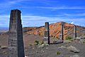
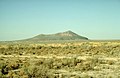
English: Media related to the Pahvant Butte (also known as Pavant Butte), a 1,126-foot (343 m) butte formed by a dormant volcano that is located in the the Pahvant Valley (also known as Pavant Valley) in the Sevier Desert in eastern Millard County, Utah, United States.
Media in category "Pahvant Butte"
The following 14 files are in this category, out of 14 total.
-
 Black Rock Desert volcanic field.jpg 1,024 × 679; 365 KB
-

-
 Fig 38 Section of Pavant Butte.jpg 608 × 214; 19 KB
-
 Fig 39 Section at base of Pavant Butte.jpg 640 × 326; 38 KB
-
 Northern FIllmore at dusk.JPG 5,184 × 3,456; 7.15 MB
-
 Pahvant Butte 1978 AR1VERE00010006.jpg 1,800 × 1,800; 468 KB
-
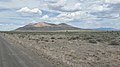 Pahvant Butte 20210519.jpg 3,200 × 1,800; 1.68 MB
-
 Pahvant Butte 3141.jpg 2,400 × 1,600; 568 KB
-
 Pahvant Butte 6768.jpg 3,264 × 2,448; 1.51 MB
-
 Pahvant Butte obelisk ring 1974 4WPG011071004.jpg 400 × 400; 45 KB
-
 Pahvant Butte Utah 2020.jpg 1,608 × 1,068; 347 KB
-
 Pahvant Butte.jpg 4,286 × 2,847; 7.69 MB
-
 Plate 40 Pavant Butte from the south.jpg 1,487 × 1,240; 460 KB
-
 Блэк Рок Десерт.jpg 1,024 × 664; 273 KB


