Category:Palaeomaps
English: Maps showing various matters represented in earlier ages of the Earth.
map of continents and mountain ranges in the past based on plate reconstructions | |||||
| Upload media | |||||
| Subclass of | |||||
|---|---|---|---|---|---|
| |||||
Subcategories
This category has the following 11 subcategories, out of 11 total.
Media in category "Palaeomaps"
The following 200 files are in this category, out of 234 total.
(previous page) (next page)-
 1 Ma paleoglobe.png 3,814 × 1,754; 414 KB
-
 100 global.png 737 × 736; 109 KB
-
 1040 Ma paleoglobe.png 3,814 × 1,754; 2.3 MB
-
 15 Ma paleoglobe.png 3,814 × 1,754; 329 KB
-
 1590 Ma.png 3,814 × 1,754; 1.54 MB
-
 170 Ma.png 3,814 × 1,754; 301 KB
-
 1740 Ma paleoglobe.png 3,814 × 1,754; 1.55 MB
-
 2000 Ma paleoglobe.png 3,814 × 1,754; 1.18 MB
-
 2050ma.png 3,814 × 1,754; 1.09 MB
-
 220 Ma paleoglobe.png 3,814 × 1,754; 291 KB
-
 2200 Ma.png 3,814 × 1,754; 997 KB
-
 220Ma Paleomap.svg 3,000 × 1,500; 154 KB
-
 237 Ma orogenies reconstruction.jpg 1,058 × 794; 107 KB
-
 237 mya continental collision.JPG 429 × 387; 55 KB
-
 2400 Ma paleoglobe.png 3,814 × 1,754; 904 KB
-
 250 Million Years Future World (Pangaea Proxima).jpg 8,000 × 5,000; 898 KB
-
 250.00 Million year in the Future-Pangaea Proxima.jpg 948 × 487; 24 KB
-
 2650 Ma paleoglobe.png 3,814 × 1,754; 740 KB
-
 275 Ma paleoglobe.png 3,814 × 1,754; 296 KB
-
 30 ma New Zealand Zealandia.png 1,104 × 721; 1.69 MB
-
 3000 Ma paleoglobe.png 3,814 × 1,754; 504 KB
-
 330 Ma paleoglobe.png 3,814 × 1,754; 290 KB
-
 370 Ma paleoglobe.png 3,814 × 1,754; 289 KB
-
 41598 2023 47011 Fig1 HTML.webp 1,994 × 1,296; 328 KB
-
 94 mya Texas Geology.JPG 506 × 456; 67 KB
-
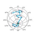
 A comparison between the true poler wander (TPW) and paleomagnetism (PM).png 2,732 × 812; 166 KB
-
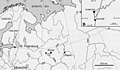
 Abfluss Megatschad.jpg 451 × 179; 31 KB
-
 Alsó devon térképe.png 459 × 270; 9 KB
-
 Alsó ordovícium térképe.png 677 × 398; 13 KB
-
 Alsó szilúr térképe.png 677 × 381; 13 KB
-
 Aptian - Acrocanthosaurus.png 779 × 404; 75 KB
-
 Aptian paleogeographical map.png 2,723 × 2,709; 3.79 MB
-
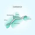
 Artistic depiction of Ur.png 1,024 × 1,024; 475 KB
-
 Atlantica-2Ga.svg 594 × 527; 32 KB
-
 Avalonia entwicklung odovizium silur.png 708 × 1,601; 34 KB
-
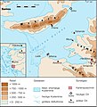
 Bartonian palaeogeography of the Tethys Realm.jpg 4,283 × 3,160; 2.24 MB
-
 Câmpia Bassiană 14.000 BP.png 469 × 485; 65 KB
-
 Leibhéal Bassian 14000 BP.jpg 500 × 517; 128 KB
-
 Bassian plain 14000 BP.jpg 500 × 517; 60 KB
-
 Bassian plain 14000 BP.svg 469 × 485; 163 KB
-
 Benue Trough faults.svg 411 × 308; 14 KB
-
 Berea Delta.png 505 × 608; 433 KB
-
 BurbankRiverMap.jpg 3,508 × 1,120; 433 KB
-
 Caledonides Km.jpg 2,625 × 1,755; 1.4 MB
-
 Cambrianmap.svg 320 × 210; 94 KB
-
 CAOB formation Hypothesis 1.png 456 × 945; 170 KB
-
 CAOB formation hypothesis 1.png 456 × 945; 175 KB
-
 Carte paléogéographique.jpg 1,126 × 838; 127 KB
-
 Cartepaleosup froid.png 300 × 306; 12 KB
-
 Cenomanian-Coniacian European fossil deposits.jpg 1,512 × 1,204; 1.26 MB
-
 Central atlantic.png 886 × 951; 424 KB
-
 Changing-Position-of-Continents-Climate-Due-To-Ocean.jpg 1,280 × 2,304; 1,020 KB
-
 Continental Drift (740 million-to-Today).gif 1,814 × 1,020; 11.01 MB
-
 ContinentinalDriftGlobe 90W.gif 360 × 360; 846 KB
-

-
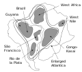
 Cratons West Gondwana and EAO v2.png 629 × 599; 157 KB
-
 Cratons West Gondwana and EAO.png 629 × 599; 153 KB
-
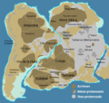
 Cratons West Gondwana IT.svg 745 × 710; 170 KB
-
 Cratons West Gondwana-es.svg 745 × 710; 196 KB
-
 Cratons West Gondwana.svg 745 × 710; 170 KB
-
 Cretaceous.png 750 × 548; 12 KB
-
 Cretacico-isotermas-y-mapamundi.svg 1,052 × 557; 76 KB
-
 Deluge-NASA.png 400 × 420; 46 KB
-
 Devonian plate tectonics.png 614 × 321; 275 KB
-
 Diagram of earth 3 billion years ago 7.png 766 × 442; 71 KB
-
 Diagram of earth 3 billion years ago.png 766 × 442; 71 KB
-
 Diagram of Kenorland.png 636 × 442; 64 KB
-
-
 Diagram of the conjectured ancient supercontinent of Kenorland.png 624 × 606; 24 KB
-
 Dire Straits FIG 01.jpg 2,612 × 3,843; 1.92 MB
-
 Distribution and dispersal of Paraceratherium.jpg 2,000 × 1,101; 1.16 MB
-
 Distribution of caseid synapsids in late Paleozoic Pangea detail.jpg 1,728 × 892; 254 KB
-
 Distribution of caseid synapsids in late Paleozoic Pangea.jpg 1,728 × 892; 266 KB
-
 Early and Late Cretaceous pterosaur assemblages.jpg 973 × 494; 104 KB
-
 Early Triassic rifting of the Atlantic basin.jpg 553 × 464; 31 KB
-

-

-
 Early-late Carnian (Late Triassic) palaeogeographic reconstruction.jpg 1,214 × 637; 206 KB
-
 Earth 720Ma.gif 1,920 × 1,080; 211 KB
-
 Ediacaran-Cambrian boundary plate tectonics.png 737 × 377; 225 KB
-
 Entrerriense Sea.png 1,256 × 1,720; 271 KB
-
 Environmental and geochemical changes of the CPE.jpg 1,050 × 1,240; 274 KB
-
 Eocene-Ocean-Surface-Circulation-Kept-Earth-Warm-During-Early-Cenozoic-Time.jpg 1,486 × 724; 709 KB
-
 Eridanos - former fluvial system.svg 551 × 483; 238 KB
-
 Evolution vom Paläo-Brahmaputra.png 1,040 × 356; 359 KB
-
 Fanerozoicobrasil1.png 3,462 × 2,294; 3.17 MB
-
 Feart-11-1160285-g007.jpg 1,281 × 1,664; 447 KB
-
 Felső kambrium térképe.png 591 × 328; 12 KB
-
 Felső karbon térképe.png 459 × 266; 9 KB
-
 Felső triász térképe.png 738 × 287; 13 KB
-
 Festland und Meer 2.jpg 1,448 × 1,142; 990 KB
-
 Festland und Meer.jpg 1,448 × 1,142; 1.03 MB
-
 Figure 1. Palaeodrainage networks of Arabia.png 2,059 × 2,240; 8.86 MB
-
 France dinantien.png 723 × 621; 125 KB
-
 France permien.png 720 × 617; 79 KB
-
 Gondwana and Laurentia.png 2,048 × 2,048; 2.56 MB
-
 Gondwana breakup.png 659 × 873; 149 KB
-
 Gondwana Map.png 2,000 × 1,414; 399 KB
-
 Gondwana, China and Siberia.png 2,048 × 2,048; 2.13 MB
-
 Hercynian structures Europe NL.svg 850 × 555; 131 KB
-
 Hercynian structures Europe-en.svg 850 × 555; 131 KB
-
 Hercynian structures Europe-es.svg 2,239 × 1,455; 516 KB
-
 Hercynian structures Europe-fr.svg 850 × 575; 129 KB
-
 Hercynian structures Europe-it.svg 850 × 555; 104 KB
-
 Hercynides CS.svg 550 × 370; 108 KB
-
 Hercynides DE.svg 550 × 370; 109 KB
-
 Hercynides EN.svg 550 × 370; 108 KB
-
 Hercynides IT.svg 550 × 370; 87 KB
-
 Hercynides Km.jpg 2,292 × 1,543; 835 KB
-
 Hercynides NL.svg 550 × 370; 108 KB
-
 Himalaya-formation.gif 234 × 424; 25 KB
-
 Hypothesis 1 v2.png 456 × 945; 202 KB
-
 Iapetus fossil evidence EN.svg 574 × 375; 109 KB
-
 Iapetus fossil evidence NL.svg 574 × 375; 109 KB
-
 Iberia 120Ma Barremian zoom.tif 361 × 268; 284 KB
-
 Image 1100.00MYA.jpg 1,280 × 734; 51 KB
-
 India 71-0 Ma.gif 442 × 743; 104 KB
-
 Induan map.jpg 1,052 × 612; 243 KB
-
 Irídium-anomáliák térképe.jpg 518 × 286; 100 KB
-
 Karoo Glaciation.png 1,250 × 771; 307 KB
-
 Kenorland breaking up.jpg 768 × 1,024; 185 KB
-
 Kenorland.jpg 194 × 259; 6 KB
-
 Kotelnich locality.jpg 1,948 × 1,136; 674 KB
-
 Lake Agassiz, southern outlet.jpg 624 × 950; 220 KB
-
 Lake Lewis flood profiles.jpg 1,046 × 786; 152 KB
-
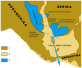
 Lake Mega Chad Topography.jpg 1,654 × 2,539; 2.51 MB
-
 Lake Monogahela.jpg 840 × 1,211; 287 KB
-
 Latmischer Golf 9000-5000 v Chr.jpg 2,834 × 3,129; 500 KB
-
 Latmischer Golf und Bafasee Entwicklung.jpg 2,834 × 3,282; 931 KB
-
 Lutetian palaeogeography of the Tethys Realm.jpg 4,283 × 3,160; 3.4 MB
-
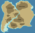
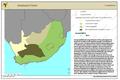
 Makgadikgadi Lake Basin OSM.png 673 × 570; 598 KB
-

-

-
 Map of the motion of the East Antarctic Shield.pdf 1,125 × 962; 9 KB
-
 Map of Ur.svg 700 × 700; 15 KB
-
 Mappa della Sicilia - Messiniano.jpg 2,772 × 1,644; 2.51 MB
-
 Mappa della Sicilia - Pleistocene inferiore.jpg 3,043 × 1,836; 3.4 MB
-
 Mappa della Sicilia - Pleistocene superiore.jpg 3,008 × 1,853; 3.37 MB
-
 Mappa della Sicilia - Pliocene.jpg 2,832 × 1,679; 2.86 MB
-
 Mappa della Sicilia - Tortoniano.jpg 2,882 × 1,732; 2.34 MB
-

-
 Mawson Kraton.png 1,139 × 2,173; 198 KB
-
 Megatschad GIS.PNG 708 × 470; 304 KB
-
 Mesosaurus sea.png 2,008 × 1,677; 1.39 MB
-
 Mid-Holocene Warm Period - globe.gif 600 × 800; 147 KB
-
 Mode 2 Europe.webp 1,889 × 1,371; 442 KB
-
 Motm 2010 07 Howiesons Poort.pdf 1,597 × 1,068; 6.6 MB
-
 Nemegtomaia maps.png 3,397 × 1,729; 4.66 MB
-
 Nemegtomaia stratigraphy.png 2,964 × 2,326; 3.85 MB
-
SIM neoproto.ogv 20 s, 512 × 480; 4.79 MB
-
 Neuenhagenerinsel.gif 591 × 436; 36 KB
-
 Neuenhagenerinseleis01.gif 591 × 436; 13 KB
-
 North america 65mya.png 994 × 1,195; 2.09 MB
-
 North america 75mya.png 1,000 × 1,195; 2.08 MB
-
 OceanGateways.png 1,155 × 806; 316 KB
-
 Orosirian continents.jpg 3,814 × 1,754; 284 KB
-
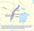 Paleo Lake Obweruka.png 611 × 565; 126 KB
-
 Paleogeographic maps east Asia. Turgai Sea.jpg 900 × 1,649; 100 KB
-
 PaleogeographicMapHimalayas.png 591 × 700; 179 KB
-

-
 Paleogeography of northern South America - Barremian-Aptian - 120Ma.jpg 826 × 761; 263 KB
-
 Paleoglobe NO 1040 mya.gif 960 × 720; 149 KB
-
 Paleoglobe NO 1260 mya.gif 960 × 720; 123 KB
-
 Paleoglobe NO 1590 mya-vector-colors.svg 960 × 720; 121 KB
-
 Paleoglobe NO 1590 mya.gif 960 × 720; 157 KB
-
 Paleoglobe NO 1740 mya.gif 960 × 720; 151 KB
-
 Paléogéo. Aalénien.jpg 860 × 599; 96 KB
-
 Paléogéo. Bajocien sup..jpg 851 × 599; 100 KB
-
 Paléogéo. Bathonien.jpg 879 × 598; 103 KB
-
 Paléogéo. Callovien inf..jpg 950 × 631; 128 KB
-
 Paléogéo. Callovien sup..jpg 950 × 665; 103 KB
-
 Pangaea assembly 430.png 1,123 × 794; 128 KB
-
 Pangaea to present Blank multilingual.jpg 623 × 777; 94 KB
-
 Pangaea to present cy.svg 623 × 777; 114 KB
-
 Pangaea to present.gif 623 × 777; 59 KB
-
 Pangea 250.png 1,543 × 2,439; 225 KB
-
 Pangea modern.png 1,200 × 1,239; 1.07 MB
-
 Pannonian Region Geological Evolution.gif 1,200 × 621; 924 KB
-
 Paratethys Megalake.pdf 8,266 × 4,722; 2.65 MB
-
 Paratethys vor 17-13 Mio Jahren.png 1,361 × 582; 501 KB
-
 Pedersen og Pedersen 2012 side 4.png 1,100 × 936; 473 KB
-
 Plate tectonic W-Méditerranée (2).jpg 901 × 768; 97 KB
-
 Pliocen i diluvium.PNG 473 × 308; 90 KB
-
 PM.Wurm.jpg 1,124 × 1,016; 309 KB
-
 Port Phillip 10,000.PNG 514 × 523; 20 KB
-

-
 Priabonian palaeogeography of the Tethys Realm.jpg 4,283 × 3,160; 2.93 MB
-
 Prognathodon distribution map.png 3,840 × 1,893; 766 KB
-
 Quaternary Coastlines A5.gif 1,275 × 770; 28 KB
-
 Recon 1.JPG 2,146 × 1,145; 227 KB
-
 Recon 2.JPG 2,169 × 1,097; 211 KB
-
 Rupelian palaeogeography of the Tethys (Paratethys) Realm.jpg 4,283 × 2,710; 2.38 MB
-
 Sarmatic area.png 1,038 × 480; 242 KB
-
 Serravallian Sea.png 2,308 × 2,142; 659 KB
-
 Silesaurid distribution.png 2,933 × 1,755; 725 KB
-
 Silurian plate tectonics.png 737 × 376; 231 KB
-
 Southern Gondwana.png 3,997 × 3,017; 1.95 MB
-
 Still picture of continental drift (740 million-to-Today).png 800 × 450; 203 KB
-
 Suomi jaakauden jalkeen.png 849 × 1,632; 69 KB
-
 Terra Australis orogen 180Ma.jpg 995 × 994; 165 KB


.jpg)


.gif)


_Eoarchean_Era.png)


_palaeogeographic_map_of_Western_Europe.jpg)
_palaeogeographic_reconstruction_and_map_of_Western_Europe.jpg)
_palaeogeographic_reconstruction.jpg)


.jpg)
.png)


_emergits_a_l%27%C3%A0rea_de_la_pen%C3%ADnsula_Ib%C3%A8rica_duran.png)


.jpg)


_Realm.jpg)


.png)


_and_paleomagnetism_(PM).png)