Category:Panoramics of mountains in New Zealand
Media in category "Panoramics of mountains in New Zealand"
The following 68 files are in this category, out of 68 total.
-
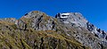
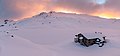 Angelus Hut in the winter, Nelson Lakes National Park, New Zealand.jpg 7,357 × 3,437; 5.13 MB
-
 Blue mountain tops NZ.jpg 8,919 × 1,751; 4.38 MB
-
 Browning Range during winter sunrise, Lake Kaniere Scenic Reserve, West Coast, New Zealand.jpg 13,814 × 4,707; 35.29 MB
-
 Canterbury, South Island banner 2.jpg 14,209 × 2,027; 19.11 MB
-
 Canterbury, South Island banner 3.jpg 10,003 × 1,431; 11.2 MB
-
 Carex secta on Lake Clearwater, Canterbury, New Zealand.jpg 14,843 × 4,567; 52.53 MB
-
 Cass Saddle, Craigieburn Forest Park, New Zealand.jpg 11,737 × 3,551; 31.69 MB
-
 Fog around Lake Heron, Taylor Range, Canterbury, New Zealand.jpg 16,968 × 3,467; 26.18 MB
-
 Freyberg Range & Spenser Mts 06.jpg 6,521 × 1,839; 7.19 MB
-
 Hakatere River valley, Canterbury, New Zealand.jpg 11,155 × 3,279; 19.82 MB
-
 Hills in Lindis Pass, New Zealand.jpg 10,014 × 4,156; 17.42 MB
-
 Lake Benmore with surrounding hills, New Zealand 01.jpg 12,107 × 3,945; 21.06 MB
-
 Lake Benmore with surrounding hills, New Zealand 02.jpg 11,904 × 3,370; 14.23 MB
-
 Lake Benmore, New Zealand.jpg 11,585 × 3,027; 22.22 MB
-
 Lake Clearwater, Canterbury, New Zealand 15.jpg 12,162 × 3,411; 22.83 MB
-
 Lake Dunstan - Clutha Arm (panorama).jpg 7,952 × 1,920; 15.97 MB
-
 Lake Dunstan - Dunstan Arm (panorama).jpg 8,176 × 1,920; 14.97 MB
-
 Lake Pukaki, Canterbury, New Zealand.jpg 16,887 × 3,760; 20.66 MB
-
 Lake Waikaremoana.jpg 6,490 × 1,384; 1.43 MB
-
 Landscape close to Dun Saddle, Bryant Range, New Zealand.jpg 19,267 × 3,285; 35.69 MB
-
 Lewis Pass, New Zealand (panorama).jpg 8,000 × 1,920; 15.13 MB
-
 Lyttelton Harbour (Whakaraupō) from Mt Ada, Canterbury, New Zealand.jpg 20,088 × 4,692; 71.05 MB
-
 Main Divide from Yeats Ridge Hut, West Coast Region, New Zealand.jpg 7,386 × 2,902; 14.42 MB
-
 Makarora River, Otago, New Zealand.jpg 15,351 × 3,174; 26.79 MB
-
 Maniniaro - Angelus Peak, Nelson Lakes National Park, New Zealand.jpg 19,835 × 5,127; 41.48 MB
-
 Milford Sound.jpg 15,456 × 1,768; 5.13 MB
-
 Morning clouds in Hakatere Conservation Park, Canterbury, New Zealand.jpg 9,543 × 2,599; 8.12 MB
-
 Mt Awful, Gillespie Pass, New Zealand 02.jpg 10,531 × 4,861; 32.07 MB
-
 Mt Bruce (left), Lagoon Saddle and Mid Hill (right), Black Range, Canterbury, New Zealand.jpg 17,264 × 4,842; 64.84 MB
-
 Mt Sefton massif, Aoraki - Mount Cook National Park, New Zealand.jpg 8,699 × 3,034; 17.34 MB
-
 Mt Somers Range from Mt Taylor.jpg 10,578 × 4,510; 31.36 MB
-
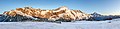 Mueller Hut with Mt Sefton and Aoraki (Mt Cook) during the sunrise.jpg 15,342 × 3,722; 34.72 MB
-
 Mystery Lake and Two Thumb Range, Canterbury, New Zealand.jpg 12,836 × 4,336; 33.64 MB
-
 New Zealand Milford Sound 2005-01-27.jpg 6,008 × 1,404; 1.25 MB
-
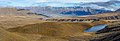
 Northern part of Lake Wanaka with surrounding mountains, New Zealand.jpg 14,714 × 2,740; 15.61 MB
-
 Panorama of Hinewai Reserve, Banks Peninsula, New Zealand 02.jpg 18,040 × 4,840; 55.83 MB
-
 Panorama of Hinewai Reserve, Banks Peninsula, New Zealand.jpg 15,517 × 2,512; 24.68 MB
-
 Panoramic mountain view from the Routeburn Track.jpg 5,542 × 894; 2.29 MB
-
 Panoramic View of Mt. Oxford Summit, North Canterbury, New Zealand (7900186690).jpg 8,192 × 1,856; 8.48 MB
-

-
 Porters Pass with Big Ben Range, Torlesse Range, New Zealand.jpg 13,666 × 3,484; 31.31 MB
-
 Remarkables 2.jpg 14,443 × 2,178; 4.46 MB
-
 Routeburn Track banner Panoramic Mountain View.jpg 4,905 × 701; 1.64 MB
-
 Seaward Kaikoura Range (view from SH 1).jpg 4,000 × 1,000; 3.96 MB
-
 South Island new banner 1.jpg 12,150 × 1,739; 9.7 MB
-
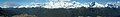
 Southern Alps from Hamilton Peak.jpg 14,742 × 1,710; 6.09 MB
-
 Sun over Lake Hawea, New Zealand.jpg 7,784 × 3,236; 7.16 MB
-
 Sunrise over Benmore Range, New Zealand.jpg 11,647 × 2,412; 9.69 MB
-
 Sunrise over Lake Wanaka from Boundary Creek, New Zealand.jpg 11,944 × 3,536; 28.72 MB
-
 Tasman Lake panorama (03-05-06-07).jpg 6,960 × 2,250; 9.84 MB
-
 Torlesse Range from Mt Torlesse, New Zealand.jpg 11,968 × 3,181; 21.03 MB
-
 Torlesse Ranges, Southern Alps, New Zealand.jpg 3,000 × 596; 2.37 MB
-
 Travis Wetland panorama, Christchurch, New Zealand.jpg 22,032 × 3,387; 50.33 MB
-
 Two Thumb Range, Canterbury, New Zealand 02.jpg 5,167 × 2,000; 7.44 MB
-
 View from Foggy Peak to Castle Hill Peak, Torlesse Range, New Zealand.jpg 15,108 × 3,183; 19.79 MB
-
 View from Foggy Peak to Craigieburn Range, New Zealand.jpg 14,209 × 2,979; 21.89 MB
-
 View from Foggy Peak to Lake Lyndon, New Zealand.jpg 11,912 × 3,294; 23.94 MB
-
 View from Isthmus Peak Trail to Lake Hawea, New Zealand 03.jpg 12,681 × 3,393; 21.61 MB
-
 View from Mt Oxford, Oxford Forest Conservation Area, Canterbury, New Zealand.jpg 10,003 × 3,292; 22.02 MB
-
 View north from Mt Richardson, New Zealand.jpg 15,821 × 2,843; 32.96 MB
-
 View of Robert Ridge Route in the winter, Nelson Lakes National Park, New Zealand.jpg 10,246 × 3,416; 15.24 MB
-
 View towards Garnet Peak from Mons Sex Millia, New Zealand.jpg 13,946 × 4,402; 43.99 MB
-
 View towards Gillespie Valley from Gillespie Pass, New Zealand 10.jpg 9,562 × 3,251; 22.73 MB
-
 View towards Gillespie Valley from Gillespie Pass, New Zealand 12.jpg 11,087 × 2,807; 20.42 MB
-
 View towards Mons Sex Millia from Garnet Peak, New Zealand.jpg 14,455 × 4,428; 54.04 MB
-
 Wanaka pan.jpg 6,723 × 1,439; 1.3 MB
-
 Wilkin River close to its confluence with Makarora River, New Zealand.jpg 6,195 × 2,985; 10.19 MB
-
 Wilkin River close to its confluence with Makarora River, Otago, New Zealand.jpg 8,324 × 3,532; 19.91 MB


.jpg)
.jpg)
.jpg)
_from_Mt_Ada,_Canterbury,_New_Zealand.jpg)
,_Lagoon_Saddle_and_Mid_Hill_(right),_Black_Range,_Canterbury,_New_Zealand.jpg)
_during_the_sunrise.jpg)
.jpg)
.jpg)
.jpg)