Category:Parish hall of All Saints, Thornton Hough
| Object location | | View all coordinates using: OpenStreetMap |
|---|
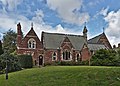
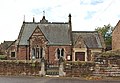
Grade II listed church hall in Wirral, England  | |||||
| Upload media | |||||
| Instance of | |||||
|---|---|---|---|---|---|
| Location | Wirral, Merseyside, North West England, England | ||||
| Heritage designation |
| ||||
 | |||||
Grade II listed former parish school and master's house behind All Saints Church, Thornton Hough. c.1866-8, by Kirk and Sons in rock-faced stone with ashlar dressings and slate roofs with tile crest.
Media in category "Parish hall of All Saints, Thornton Hough"
The following 4 files are in this category, out of 4 total.
-
 All Saints church hall, Thornton Hough.jpg 4,703 × 2,609; 13.69 MB
-
 Parish Hall (218741263).jpeg 2,048 × 1,745; 1.28 MB
-
 Parish hall of All Saints, Thornton Hough.jpg 4,795 × 3,455; 23.46 MB
-
 Parish Hall, Thornton Hough.jpg 4,972 × 3,435; 18.57 MB

.jpeg)
