Category:Penn, West Midlands

English: Penn is an area now divided between the City of Wolverhampton and South Staffordshire district. The population of the Wolverhampton Ward taken at the 2011 census was 12,718.[1] Originally, it was a village in the historic county of Staffordshire. There is considerable confusion about exactly which areas fall within Penn. In 19th century censuses, Merry Hill, Bradmore and Warstones are understood to form part of Penn, although these areas are generally understood to be separate today. However, there has never been any doubt that the two historic settlements of Upper and Lower Penn form the core of the area.
area in Wolverhampton, West Midlands, UK  | |||||
| Upload media | |||||
| Instance of | |||||
|---|---|---|---|---|---|
| Location | Wolverhampton, City of Wolverhampton, West Midlands, England | ||||
| Different from | |||||
 | |||||
Subcategories
This category has the following 4 subcategories, out of 4 total.
Media in category "Penn, West Midlands"
The following 37 files are in this category, out of 37 total.
-
 -2021-01-25 Snow on Colton Hills near Penn, Wolverhampton.jpg 1,440 × 960; 1.7 MB
-

-
 Barn at farm on Pennwood Lane, Penn - geograph.org.uk - 288275.jpg 600 × 480; 229 KB
-
 Boundary fence at Penn, Wolverhampton - geograph.org.uk - 1299530.jpg 640 × 455; 142 KB
-
 Bowling Green, Penn, Wolverhampton - geograph.org.uk - 433736.jpg 640 × 440; 148 KB
-
 Buckingham Road, Penn, Wolverhampton - geograph.org.uk - 1626649.jpg 640 × 482; 140 KB
-
 Buckingham Road, Penn, Wolverhampton - geograph.org.uk - 1651247.jpg 640 × 480; 136 KB
-
 Buckingham Road, Penn, Wolverhampton - geograph.org.uk - 790124.jpg 640 × 420; 146 KB
-
 Buckingham Road, Penn, Wolverhampton - geograph.org.uk - 796205.jpg 640 × 425; 124 KB
-
 Cricket field at Penn, Wolverhampton - geograph.org.uk - 1300125.jpg 640 × 425; 124 KB
-

-
 Muchall Park, Penn, Wolverhampton - geograph.org.uk - 1087294.jpg 640 × 447; 108 KB
-

-

-
 Pennhouse Avenue, Penn, Wolverhampton - geograph.org.uk - 1147436.jpg 640 × 391; 149 KB
-
 Pinfold Lane in Penn, Wolverhampton - geograph.org.uk - 1751888.jpg 640 × 470; 150 KB
-
 Sandringham Road, Penn, Wolverhampton - geograph.org.uk - 1651204.jpg 640 × 464; 139 KB
-
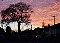
 Sunset over Buckingham Road in Penn, Wolverhampton - geograph.org.uk - 3772732.jpg 1,024 × 1,024; 596 KB
-
 Sunset over Penn rooftops, Wolverhampton - geograph.org.uk - 3774137.jpg 1,280 × 608; 355 KB
-
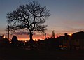 Sunset over Penn, Wolverhampton - geograph.org.uk - 2761788.jpg 1,024 × 735; 384 KB
-
 Sunset over Penn, Wolverhampton - geograph.org.uk - 2964231.jpg 1,280 × 1,280; 1.12 MB
-
 Sunset over Penn, Wolverhampton - geograph.org.uk - 3771999.jpg 1,024 × 764; 346 KB
-
 Sunset over Penn, Wolverhampton - geograph.org.uk - 3772005.jpg 1,024 × 744; 463 KB
-
 Sunset over Penn, Wolverhampton - geograph.org.uk - 3772726.jpg 788 × 1,024; 506 KB
-
 Sunset over Penn, Wolverhampton - geograph.org.uk - 3774122.jpg 794 × 1,024; 457 KB
-

-
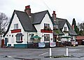 The Mount Tavern, Penn, Wolverhampton - geograph.org.uk - 664098.jpg 1,600 × 1,150; 1.5 MB
-
 The Old Stags Head near Penn Common - geograph.org.uk - 288244.jpg 600 × 450; 205 KB
-
 Westbourne Road, Penn, Wolverhampton - geograph.org.uk - 796212.jpg 640 × 452; 143 KB
-
 Westbourne Road, Penn, Wolverhampton - geograph.org.uk - 980537.jpg 640 × 420; 144 KB
-
 Westbourne Road, Penn, Wolverhampton - geograph.org.uk - 980549.jpg 640 × 483; 137 KB
-
 Westminster Avenue, Penn, Wolverhampton - geograph.org.uk - 1651169.jpg 640 × 470; 125 KB
-
 Westminster Avenue, Penn, Wolverhampton - geograph.org.uk - 1651192.jpg 640 × 468; 139 KB
-
 Woodland Cottages, Penn, Wolverhampton - geograph.org.uk - 683163.jpg 640 × 519; 159 KB
-
 Woodland Walk, Penn, Wolverhampton - geograph.org.uk - 1147406.jpg 640 × 456; 150 KB
-
 Woodland Walk, Penn, Wolverhampton - geograph.org.uk - 1147407.jpg 640 × 453; 149 KB
-
 Modern Housing, Penn, Wolverhampton - geograph.org.uk - 683185.jpg 640 × 372; 119 KB


_on_%22Royal%22_Estate,_Penn,_Wolverhampton_-_geograph.org.uk_-_683232.jpg)


