Category:Pentillie, Cornwall
| Object location | | View all coordinates using: OpenStreetMap |
|---|
Country house in Cornwall, England, UK  | |||||
| Upload media | |||||
| Instance of | |||||
|---|---|---|---|---|---|
| Location | Pillaton, Cornwall, South West England, England | ||||
| Heritage designation |
| ||||
| official website | |||||
 | |||||
English: Pentillie is a grade II* listed country house and estate, located on the banks of the River Tamar in Pillaton, near to St Mellion, in Cornwall, England, in the United Kingdom. The nearby village of St Dominick at one time belonged to the estate.
This is a category about listed building number 1140189. |
Media in category "Pentillie, Cornwall"
The following 13 files are in this category, out of 13 total.
-

-

-
 Entrance to Pentillie Castle, near Saltash - geograph.org.uk - 89277.jpg 640 × 427; 241 KB
-
 Field on Pentillie Castle estate - geograph.org.uk - 1205437.jpg 640 × 480; 61 KB
-

-
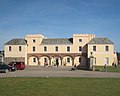 Pentillie Castle - geograph.org.uk - 1205418.jpg 640 × 511; 64 KB
-

-
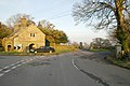
 Pentillie Castle Lodge - geograph.org.uk - 338203.jpg 640 × 480; 101 KB
-
 Pond on Pentillie Castle estate - geograph.org.uk - 1205412.jpg 480 × 640; 138 KB
-

-

-
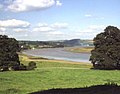 The Pentillie estate - geograph.org.uk - 997050.jpg 640 × 502; 73 KB
-
 The sawmill on Pentillie Castle estate - geograph.org.uk - 1205403.jpg 640 × 480; 128 KB


