Category:Pfarrhaus (Trub)
| Object location | | View all coordinates using: OpenStreetMap |
|---|
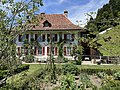
residential building and part of a building ensemble in Trub in the canton of Bern, Switzerland  | |||||
| Upload media | |||||
| Instance of | |||||
|---|---|---|---|---|---|
| Part of | |||||
| Location | Trub, Emmental administrative district, Emmental-Oberaargau administrative region, Bern, Switzerland | ||||
| Street address |
| ||||
| Inception |
| ||||
| Significant event |
| ||||
 | |||||
Media in category "Pfarrhaus (Trub)"
The following 3 files are in this category, out of 3 total.
-
 CH-NB - Trub - Collection Gugelmann - GS-GUGE-WEIBEL-D-139b.tif 5,925 × 3,889, 2 pages; 51.64 MB
-
 Trub Pfarrhaus.JPG 3,918 × 2,938; 4.72 MB
-
 Trub Pfarrhaus2.JPG 3,713 × 2,731; 2.94 MB

