Category:Pfarrkirche Nauders
| Object location | | View all coordinates using: OpenStreetMap |
|---|
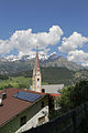
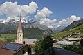
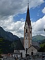
church building in Nauders, Austria  | |||||
| Upload media | |||||
| Instance of | |||||
|---|---|---|---|---|---|
| Location | Nauders, Landeck District, Tyrol, Austria | ||||
| Street address |
| ||||
| Architectural style | |||||
| Heritage designation | |||||
 | |||||
| This category shows the protected monument with the number 39858 in Austria. (Commons, de, Wikidata) |
|
This category shows the remarkable cultural object in the Austrian state of Tyrol listed by the Tyrolean Art Cadastre with the ID
28745. (on tirisMaps, pdf, more images on Commons, Wikidata) |
Media in category "Pfarrkirche Nauders"
The following 11 files are in this category, out of 11 total.
-
 AT 39858 Kath. Pfarrkirche hl. Valentin, Nauders-7693.jpg 3,648 × 5,472; 9.32 MB
-
 AT 39858 Kath. Pfarrkirche hl. Valentin, Nauders-7694.jpg 3,509 × 5,263; 9.03 MB
-
 AT 39858 Kath. Pfarrkirche hl. Valentin, Nauders-7695.jpg 3,540 × 5,310; 8.16 MB
-
 AT 39858 Kath. Pfarrkirche hl. Valentin, Nauders-7699.jpg 3,648 × 5,472; 7.21 MB
-
 AT 39858 Kath. Pfarrkirche hl. Valentin, Nauders-7701.jpg 5,472 × 3,648; 7.86 MB
-
 Kath. Pfarrkirche hl. Valentin.JPG 3,088 × 2,056; 2.4 MB
-
 Nauders, Katholische Kirche hl. Valentin.JPG 3,088 × 2,056; 1.89 MB
-
 Nauders-Pfarrkirche.JPG 3,240 × 4,320; 4.66 MB
-
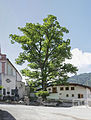 ND 6 8 Sommerlinde Nauders-7681-Bearbeitet.jpg 3,648 × 4,812; 9.01 MB
-
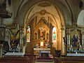 Pfarrkirche Nauders, Altarraum.JPG 4,000 × 3,000; 2.53 MB
-
 Sommerlinde Nauders 03.JPG 3,456 × 5,184; 9.62 MB


