Category:Pfarrkirche Obritzberg
| Object location | | View all coordinates using: OpenStreetMap |
|---|
| This category shows the protected monument with the number 55232 in Austria. (Commons, de, Wikidata) |
cemetery in Lower Austria, Austria  | |||||
| Upload media | |||||
| Instance of | |||||
|---|---|---|---|---|---|
| Named after | |||||
| Location | Obritzberg-Rust, Sankt Pölten District, Lower Austria, Austria | ||||
| Street address |
| ||||
| Heritage designation | |||||
 | |||||
Media in category "Pfarrkirche Obritzberg"
The following 16 files are in this category, out of 16 total.
-
 Obritzberg Kirche01.jpg 3,648 × 2,736; 4.99 MB
-
 Obritzberg Kirche02.jpg 2,736 × 3,648; 3.34 MB
-
 Obritzberg Kirche03.jpg 2,736 × 3,648; 3.3 MB
-
 Obritzberg Kirche04.jpg 2,736 × 3,648; 3.19 MB
-
 Obritzberg Kirche05.jpg 2,736 × 3,648; 3.48 MB
-
 Obritzberg Kirche06.jpg 3,648 × 2,736; 3.93 MB
-
 Obritzberg.jpg 2,262 × 3,425; 6.23 MB
-
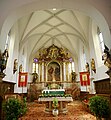 Pfarrkirche Obritzberg - Altar.jpg 3,895 × 4,199; 3.97 MB
-
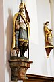 Pfarrkirche Obritzberg - Florian.jpg 2,191 × 3,273; 2.09 MB
-
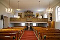
 Pfarrkirche Obritzberg - Innenansicht.JPG 3,872 × 2,592; 3.65 MB
-
 Pfarrkirche Obritzberg - JohannesNepomuk.JPG 2,112 × 3,155; 1.84 MB
-
 Pfarrkirche Obritzberg - Leonhard.JPG 2,276 × 3,400; 2.55 MB
-
 Pfarrkirche Obritzberg - Leopold.JPG 2,345 × 3,502; 2.62 MB
-
 Pfarrkirche Obritzberg - Rückseite.jpg 3,872 × 2,592; 3.37 MB
-
 Pfarrkirche Obritzberg - Seitenaltar - Maria.JPG 2,189 × 3,270; 2.8 MB
-
 Pfarrkirche Obritzberg - Seitenaltar - Sebastian.JPG 2,592 × 3,872; 3.39 MB


