Category:Pfarrkirche St. Michael (Hägglingen)
| Object location | | View all coordinates using: OpenStreetMap |
|---|
church building in Hägglingen in the canton of Aargau, Switzerland   | |||||
| Upload media | |||||
| Instance of | |||||
|---|---|---|---|---|---|
| Part of | |||||
| Named after | |||||
| Location | Hägglingen, Bremgarten District, Aargau, Switzerland | ||||
| Street address |
| ||||
| Has part(s) | |||||
| Heritage designation | |||||
| Inception |
| ||||
| official website | |||||
 | |||||
Subcategories
This category has only the following subcategory.
P
Media in category "Pfarrkirche St. Michael (Hägglingen)"
The following 6 files are in this category, out of 6 total.
-
 2022-Haegglingen-Fresko.jpg 1,920 × 1,511; 2.5 MB
-
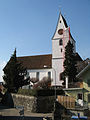
 2022-Haegglingen-Kirche.jpg 1,371 × 1,920; 2.15 MB
-
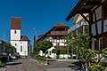 2022-Haegglingen-Poststrasse.jpg 1,920 × 1,280; 2.24 MB
-
 Hägglingen 399.JPG 3,888 × 2,592; 2.77 MB
-
 Hägglingen Kirche.jpg 1,500 × 2,000; 621 KB
-
 Kirche in Hägglingen.jpg 666 × 1,000; 195 KB


