Category:Pfarrkirche St. Radegundis, St. Radegund bei Graz
| Object location | | View all coordinates using: OpenStreetMap |
|---|
| This category shows the protected monument with the number 57690 in Austria. (Commons, de, Wikidata) |
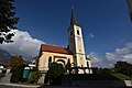
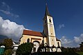
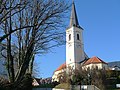
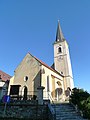
Parish church in Sankt Radegund bei Graz, Austria .JPG) Southeast view of the parish church of St. Radegund bei Graz | |||||
| Upload media | |||||
| Instance of | |||||
|---|---|---|---|---|---|
| Location | Sankt Radegund bei Graz, Graz-Umgebung District, Styria, Austria | ||||
| Street address |
| ||||
| Heritage designation | |||||
 | |||||
Subcategories
This category has only the following subcategory.
Media in category "Pfarrkirche St. Radegundis, St. Radegund bei Graz"
The following 9 files are in this category, out of 9 total.
-
 Pfarrkirche Sankt Radegundis St Radegund bei Graz 01.jpg 6,000 × 4,000; 10.8 MB
-
 Pfarrkirche Sankt Radegundis St Radegund bei Graz 02.jpg 4,000 × 6,000; 10.48 MB
-
 Pfarrkirche Sankt Radegundis St Radegund bei Graz 03.jpg 6,000 × 4,000; 10.83 MB
-
 Pfarrkirche Sankt Radegundis St Radegund bei Graz 04.jpg 6,000 × 4,000; 10.64 MB
-
 Pfarrkirche Sankt Radegundis St Radegund bei Graz 05.jpg 4,000 × 6,000; 11.53 MB
-
 St. Radegund bei Graz - Kirche (a).JPG 2,624 × 3,937; 5.81 MB
-
 St. Radegund bei Graz - Kirche (b).JPG 5,200 × 3,900; 9.86 MB
-
 St.Radegund Pfk L1300131.JPG 3,648 × 2,736; 4.68 MB
-
 St.Radegund Pfk L1300138.JPG 2,736 × 3,648; 3.35 MB


.JPG)

