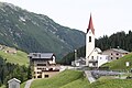
Category:Pfarrkirche hl. Sebastian, Warth
| Object location | | View all coordinates using: OpenStreetMap |
|---|
church building in Warth, Austria  | |||||
| Upload media | |||||
| Instance of | |||||
|---|---|---|---|---|---|
| Named after | |||||
| Location | Warth, Bregenz District, Vorarlberg, Austria | ||||
| Heritage designation | |||||
| Religion or worldview | |||||
 | |||||
Subcategories
This category has only the following subcategory.
Media in category "Pfarrkirche hl. Sebastian, Warth"
The following 14 files are in this category, out of 14 total.
-
 Hochtannbergstraße 01.JPG 4,530 × 2,472; 4.55 MB
-
 Katholische Pfarrkirche Heiliger Sebastian in Warth.JPG 2,736 × 3,648; 3.48 MB
-
 Pfarrkirche Warth 1.jpg 4,288 × 2,848; 4.94 MB
-
 Pfarrkirche Warth 2.jpg 2,848 × 4,288; 4.51 MB
-
 Warth (Vorarlberg), Blick auf Zentrum, Sommer 2016.jpg 4,000 × 2,742; 3 MB
-
 Warth - panoramio.jpg 3,072 × 2,304; 2.69 MB
-
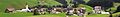 Warth Banner.jpg 3,995 × 571; 813 KB
-
 Warth Hl Sebastian.JPG 2,651 × 2,651; 4.33 MB
-
 Warth Vlbg hl Sebastian.JPG 3,551 × 5,128; 8.74 MB
-
 Warth Vorarlberg 006.JPG 3,456 × 2,304; 3.26 MB
-
 Warth Vorarlberg 008.JPG 3,456 × 2,304; 3.79 MB
-
 Warth Vorarlberg 009.JPG 3,456 × 2,304; 3.37 MB
-
 Warth Vorarlberg 014.JPG 3,456 × 2,304; 3.18 MB
-
 Warth2005-08.jpg 2,304 × 1,728; 1.68 MB


,_Blick_auf_Zentrum,_Sommer_2016.jpg)


