Category:Philatelic and postal maps of Ireland
Subcategories
This category has the following 2 subcategories, out of 2 total.
Media in category "Philatelic and postal maps of Ireland"
The following 10 files are in this category, out of 10 total.
-
-
-

-
 Wilson's 1820 Map of the Roads of Ireland with all the Post Towns.jpg 4,246 × 5,631; 5.59 MB
-
 1832 Irish Postal Circulation Map.jpg 1,497 × 1,966; 710 KB
-
 New Map of Ireland 1840 by Pigot & Co (cropped).jpg 1,802 × 2,509; 6.5 MB
-
 New Map of Ireland 1840 by Pigot & Co.jpg 2,100 × 2,716; 7.16 MB
-
 1846 Lewis's Post Town map of Ireland.jpg 8,478 × 10,669; 16.69 MB
-
 1907 GPO Circulation map of Ireland.jpg 1,100 × 1,343; 348 KB
-
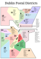 DublinPC.svg 744 × 1,052; 52 KB

.jpg)
.jpg)


.jpg)


