Category:Photos from Panoramio ID 6075601

Media in category "Photos from Panoramio ID 6075601"
The following 36 files are in this category, out of 36 total.
-
 Approaching I-215 - panoramio.jpg 1,600 × 1,200; 552 KB
-
 Begin North UT-148 to Cedar Breaks, Brian Head - panoramio.jpg 1,600 × 1,200; 801 KB
-
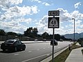 END UT-48 Shield - panoramio.jpg 1,600 × 1,200; 530 KB
-
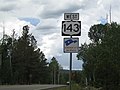 Error "US-143" Shield near Mammoth Creek - panoramio.jpg 1,600 × 1,200; 501 KB
-
 Error "US-190" Shield at the West end of UT-210 - panoramio.jpg 1,600 × 1,200; 520 KB
-
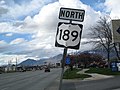 First NB US-189 Shield - panoramio.jpg 1,600 × 1,200; 520 KB
-
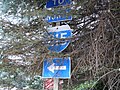
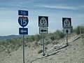
 Hidden UT-73-145 Junction Shields - panoramio.jpg 1,600 × 1,200; 808 KB
-
 JCT UT-21 on BL-15-UT-160 in Beaver - panoramio.jpg 1,600 × 1,200; 501 KB
-
 Junction UT-129 on EB UT-92 - panoramio.jpg 1,600 × 1,200; 672 KB
-
 Junction UT-198 in Payson - panoramio.jpg 1,600 × 1,200; 603 KB
-
 Last UT-48 Shield West of Bangerter Hwy (UT-154) - panoramio.jpg 1,600 × 1,200; 563 KB
-
 Misplaced I-215 Shields - panoramio.jpg 1,600 × 1,200; 647 KB
-
 North US-189 (University Ave) with a Covered Shield - panoramio.jpg 1,600 × 1,200; 527 KB
-
 North US-189 With a Yet-to-be-Numbered Route Shield - panoramio.jpg 1,600 × 1,200; 668 KB
-
 North UT-147 Beginning where UT-141 Ends - panoramio.jpg 1,600 × 1,200; 538 KB
-
 Old Hidden I-215 Shield - panoramio.jpg 1,600 × 1,200; 1.09 MB
-
 Old UT-209 Milepost 6 - panoramio.jpg 1,600 × 1,200; 597 KB
-
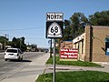 Solo UT-68 Shield, N from 7800 S - panoramio.jpg 1,600 × 1,200; 621 KB
-
 South UT-148 near Cedar Breaks - panoramio.jpg 1,600 × 1,200; 744 KB
-
 Updated UT-209 Milepost 10 - panoramio.jpg 1,600 × 1,200; 527 KB
-
 UT-111 at WB Old UT-48 (now UT-209) Shield - panoramio.jpg 1,600 × 1,200; 507 KB
-
 UT-111-EB Old UT-48 (New UT-209) Junction - panoramio.jpg 1,600 × 1,200; 617 KB
-
 UT-143 East near Mammoth Creek - panoramio.jpg 1,600 × 1,200; 654 KB
-
 UT-160-BL-15 North in Beaver - panoramio.jpg 1,600 × 1,200; 545 KB
-
 UT-198 at the South (or West) end of UT-115 in Payson - panoramio.jpg 1,600 × 1,200; 1.04 MB
-
 UT-209-210 Junction - panoramio.jpg 1,600 × 1,200; 504 KB
-
 UT-266 in Taylorsville - panoramio.jpg 1,600 × 1,200; 510 KB
-
 UT-68 Crossways at 14600 S (UT-140) - panoramio.jpg 1,600 × 1,200; 536 KB
-
 UT-68 Junction, UT-140 End - panoramio.jpg 1,600 × 1,200; 612 KB
-
 UT-68-140 Junction Assembly, Looking South - panoramio.jpg 1,600 × 1,200; 535 KB
-
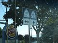 UT-68-171 Junction - panoramio.jpg 1,600 × 1,200; 556 KB
-
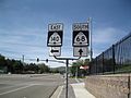
 UT-68-209 Junction, Looking South - panoramio.jpg 1,600 × 1,200; 769 KB
-
 UT-68-48 Implicit Duplex 1 - panoramio.jpg 1,600 × 1,200; 557 KB
-
 UT-68-48 Implicit Duplex 3 - panoramio.jpg 1,600 × 1,200; 558 KB
-
 UT-85 (Lehi's 2100 N) at Redwood Rd - panoramio.jpg 1,600 × 1,200; 660 KB
-
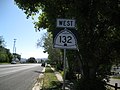 West UT-132 in Nephi - panoramio.jpg 1,600 × 1,200; 618 KB


_-_panoramio.jpg)

_with_a_Covered_Shield_-_panoramio.jpg)


_Shield_-_panoramio.jpg)
_Junction_-_panoramio.jpg)


_end_of_UT-115_in_Payson_-_panoramio.jpg)


_-_panoramio.jpg)


_at_Redwood_Rd_-_panoramio.jpg)
