Category:Plantsoen 71, Leiden
| Object location | | View all coordinates using: OpenStreetMap |
|---|
 | |||||
| Upload media | |||||
| Instance of | |||||
|---|---|---|---|---|---|
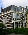
| Location | Leiden, South Holland, Netherlands | ||||
| Street address |
| ||||
| Heritage designation |
| ||||
 | |||||
|
This is a category about rijksmonument number 515105
|
| Address |
|
Media in category "Plantsoen 71, Leiden"
The following 3 files are in this category, out of 3 total.
-
 En lager, overzicht - Leiden - 20137078 - RCE.jpg 1,197 × 1,200; 417 KB
-
 Plantsoen 71.jpg 2,046 × 2,592; 2.02 MB
-
 Voorgevel - Leiden - 20137079 - RCE.jpg 1,190 × 1,200; 304 KB

