Category:Point Danger, Queensland
point in Australia  | |||||
| Upload media | |||||
| Instance of | |||||
|---|---|---|---|---|---|
| Location | AUS | ||||
| Located in or next to body of water | |||||
| Elevation above sea level |
| ||||
 | |||||
Media in category "Point Danger, Queensland"
The following 13 files are in this category, out of 13 total.
-
 Admiralty Chart No 1028 Evans Head to Danger Pt., New South Wales, Published1866.jpg 11,143 × 16,345; 56.06 MB
-
 Admiralty Chart No 1029 Danger Pt. to Cape Moreton, Queensland, Published 1869.jpg 11,125 × 16,281; 65.92 MB
-
 Admiralty Chart No 1071 Three plans on the East Coast of Australia, Published 1831.jpg 4,087 × 3,042; 2.85 MB
-
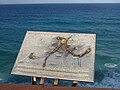 Map at Point Danger Lookout, Coolangatta, Queensland.jpg 3,264 × 2,448; 2.46 MB
-
 Point Danger and Tweed River mouth, Tweed Heads IMGP1701.jpg 3,008 × 2,000; 2.56 MB
-
 Point Danger and Tweed River mouth, Tweed Heads IMGP1702.jpg 3,008 × 2,000; 2.83 MB
-
 QLD-NSW border trig point - panoramio.jpg 2,304 × 3,072; 1.25 MB
-
 Queensland State Archives 2111 Point Danger Coolangatta c 1934.png 720 × 421; 252 KB
-
 Queensland State Archives 2114 Point Danger Coolangatta c 1934.png 720 × 426; 258 KB
-
 Queensland State Archives 2174 Point Danger Coolangatta c 1934.png 720 × 494; 271 KB
-

-
 StateLibQld 1 298499 Point Danger Quarry, ca. 1903.jpg 1,000 × 758; 138 KB
-
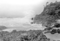
 View south from Point Danger Lookout, Coolangatta, Queensland.jpg 3,264 × 2,448; 2.39 MB


