Category:Political maps of Medina County, Ohio as of the 2000 United States Census
Media in category "Political maps of Medina County, Ohio as of the 2000 United States Census"
The following 31 files are in this category, out of 31 total.
-
 Map of Medina County Ohio Highlighting Brunswick City.png 526 × 492; 24 KB
-
 Map of Medina County Ohio Highlighting Brunswick Hills Township.png 526 × 492; 24 KB
-
 Map of Medina County Ohio Highlighting Chatham Township.png 526 × 492; 24 KB
-
 Map of Medina County Ohio Highlighting Chippewa Lake Village.png 526 × 492; 24 KB
-
 Map of Medina County Ohio Highlighting Creston Village.png 526 × 492; 24 KB
-
 Map of Medina County Ohio Highlighting Gloria Glens Park Village.png 526 × 492; 24 KB
-
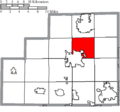
 Map of Medina County Ohio Highlighting Granger Township.png 526 × 492; 24 KB
-
 Map of Medina County Ohio Highlighting Guilford Township.png 526 × 492; 24 KB
-
 Map of Medina County Ohio Highlighting Harrisville Township.png 526 × 492; 24 KB
-
 Map of Medina County Ohio Highlighting Hinckley Township.png 526 × 492; 24 KB
-
 Map of Medina County Ohio Highlighting Homer Township.png 526 × 492; 24 KB
-
 Map of Medina County Ohio Highlighting Lafayette Township.png 526 × 492; 24 KB
-
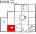
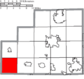
 Map of Medina County Ohio Highlighting Litchfield Township.png 526 × 492; 24 KB
-
 Map of Medina County Ohio Highlighting Liverpool Township.png 526 × 492; 24 KB
-
 Map of Medina County Ohio Highlighting Lodi Village.png 526 × 492; 24 KB
-
 Map of Medina County Ohio Highlighting Medina City.png 526 × 492; 24 KB
-
 Map of Medina County Ohio Highlighting Medina Township.png 526 × 492; 24 KB
-
 Map of Medina County Ohio Highlighting Montville Township.png 526 × 492; 24 KB
-
 Map of Medina County Ohio Highlighting Rittman City.png 526 × 492; 24 KB
-
 Map of Medina County Ohio Highlighting Seville Village.png 526 × 492; 24 KB
-
 Map of Medina County Ohio Highlighting Sharon Township.png 526 × 492; 24 KB
-
 Map of Medina County Ohio Highlighting Spencer Township.png 526 × 492; 24 KB
-
 Map of Medina County Ohio Highlighting Spencer Village.png 526 × 492; 24 KB
-
 Map of Medina County Ohio Highlighting Wadsworth City.png 526 × 492; 24 KB
-
 Map of Medina County Ohio Highlighting Wadsworth Township.png 526 × 492; 24 KB
-
 Map of Medina County Ohio Highlighting Westfield Center Village.png 526 × 492; 24 KB
-
 Map of Medina County Ohio Highlighting Westfield Township.png 526 × 492; 24 KB
-
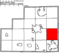
 Map of Medina County Ohio Highlighting York Township.png 526 × 492; 24 KB
-
 Map of Medina County Ohio With Municipal and Township Labels.PNG 526 × 492; 43 KB
-
 Map of Medina County, Ohio No Text, Municipalities Distinct.png 526 × 492; 24 KB
-
 Map of Medina County, Ohio No Text.png 526 × 492; 23 KB


