Category:Polyconic projection
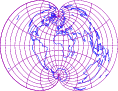
English: The polyconic projections are a group of map projections resulting by mapping the surface of Earth to multiple cones. Example: rectangular polyconic or War Office projection.
Deutsch: Die polykonischen Projektionen oder Vielkegelentwürfe sind eine Gruppe von Kartennetzentwürfen, die durch Abbildung der Erdoberfläche mittels mehrerer Kegel als Hilfskörper entstehen. Beispiel: orthogonale polykonische Projektion (engl. auch War Office genannt).
- (en) Polyconic projection
- (ca) Projecció cònica múltiple
- (es) Proyección cónica múltiple
- (ja) 多円錐図法
- (nl) Polyconische projectie
English: This map-projection-related category exists in the following hierarchy:
- Category:Map projections
- Category:Maps by projection
- Category:polyconic projection – media related to the polyconic projection other than maps
- Category:Maps with polyconic projection (“Category:polyconic projections”) – maps made using the polyconic projection
Subcategories
This category has only the following subcategory.
P
- Maps with polyconic projection (23 F)
Media in category "Polyconic projection"
The following 2 files are in this category, out of 2 total.
-
 Polyconic projection 118.png 118 × 91; 13 KB
-
 Usgs map polyconic.PNG 377 × 181; 31 KB

