Category:Pont de Saint-Maurice-de-Sorgues
| Object location | | View all coordinates using: OpenStreetMap |
|---|
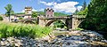
18th century bridge, in Saint-Maurice-de-Sorgues, commune attached to Fondamente (Aveyron)  | |||||
| Upload media | |||||
| Instance of | |||||
|---|---|---|---|---|---|
| Location | Fondamente, canton of Cornus | ||||
| Street address |
| ||||
| Crosses | |||||
| Heritage designation |
| ||||
 | |||||
Media in category "Pont de Saint-Maurice-de-Sorgues"
The following 14 files are in this category, out of 14 total.
-
 Bridge in Saint-Maurice-de-Sorgues 01.jpg 5,406 × 3,503; 18.34 MB
-
 Bridge in Saint-Maurice-de-Sorgues 02.jpg 4,486 × 3,483; 13.28 MB
-
 Bridge in Saint-Maurice-de-Sorgues 03.jpg 3,553 × 5,329; 13.32 MB
-
 Bridge in Saint-Maurice-de-Sorgues 04.jpg 3,516 × 2,680; 9.97 MB
-
 Bridge in Saint-Maurice-de-Sorgues 05.jpg 6,098 × 2,669; 13.49 MB
-
 Bridge in Saint-Maurice-de-Sorgues 06.jpg 4,037 × 2,691; 8.92 MB
-
 Saint Maurice de Sorgues-Arches du lit majeur-20140628.jpg 5,472 × 3,648; 9.47 MB
-
 Saint Maurice de Sorgues-Chaussée du Pont-20140628.jpg 5,472 × 3,648; 11.85 MB
-
 Saint Maurice de Sorgues-Croix de chemin-20140628.jpg 5,472 × 3,648; 7.65 MB
-
 Saint Maurice de Sorgues-Pont PAm-20140628.jpg 11,000 × 3,500; 11.69 MB
-
 Saint Maurice de Sorgues-Pont PAv-20140628.jpg 6,500 × 3,500; 7.08 MB
-
 Saint Maurice de Sorgues-Pont VAm-20140628.jpg 5,472 × 3,648; 10.89 MB
-
 Saint Maurice de Sorgues-Pont VAv-20140628.jpg 5,472 × 3,648; 8.53 MB
-
 Saint-Maurice-de-Sorgues pont.jpg 360 × 240; 69 KB


