Category:Population maps of the European Union
Media in category "Population maps of the European Union"
The following 10 files are in this category, out of 10 total.
-
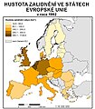 Choropleth map.jpg 700 × 800; 228 KB
-
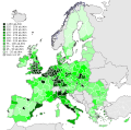
 Population density european union.png 1,046 × 842; 101 KB
-
 EU NUTS 2 population density 2007 Diagonal continental.svg 451 × 451; 2.32 MB
-
 EU NUTS 2 population density 2007.svg 850 × 600; 2.09 MB
-
 Density of Population in EU 2014-it.svg 609 × 600; 2.15 MB
-
 Density of Population in EU 2014.svg 609 × 600; 2.15 MB
-
 Population density by NUTS 3 region (2017).svg 950 × 830; 9.06 MB
-
 EU Pop2008 1024-not contiguity.svg 600 × 620; 271 KB
-
 EU Pop2008 1024.PNG 1,536 × 1,534; 249 KB
-
 EU-metropoles-sans-bordures.png 1,220 × 1,012; 93 KB


.svg)


