Category:Porta Portuensis (Rome)
| Object location | | View all coordinates using: OpenStreetMap |
|---|
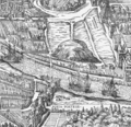
one of the southern gates of the Aurelian Walls of Rome.  Porta Portuensis prima della sua demolizione, raffigurata in un'incisione di Giuseppe Vasi realizzata nel 1743 sulla scorta di disegni precedenti. | |||||
| Upload media | |||||
| Instance of | |||||
|---|---|---|---|---|---|
| Part of | |||||
| Location | Trastevere, Municipio I, Rome, Metropolitan City of Rome, Lazio, Italy | ||||
 | |||||
Media in category "Porta Portuensis (Rome)"
The following 4 files are in this category, out of 4 total.
-
 Porta Portuensis.jpg 322 × 260; 23 KB
-
 Hugues Pinard 1555 Ausschnitt.jpg 1,115 × 688; 626 KB
-

-
 Testaccio 1625.png 1,970 × 1,900; 4.15 MB


