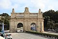
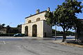
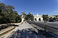
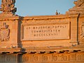
Category:Porte des Bombes
| Object location | | View all coordinates using: OpenStreetMap |
|---|
gate in Floriana, Malta _02_ies.jpg) | |||||
| Upload media | |||||
| Instance of | |||||
|---|---|---|---|---|---|
| Location | Floriana, Port Region (Port), Malta | ||||
| Street address |
| ||||
| Architectural style | |||||
| Architect |
| ||||
| Owned by | |||||
| Heritage designation |
| ||||
| Inception |
| ||||
 | |||||
Timeline of the development of the road through and around Portes Des Bombes and the shifting of the 'Bombes' columns:
(Ref North Bombe on the left as you look towards Valletta, South Bombe on the right).
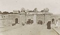
1721 - Original single arch gate leading on to a lunette that had a narrow entrance through the defensive wall with the Bombes either side.
1868 - The addition of a 2nd arch on the LH side (facing Valletta). South Bombe moved and a central column added. Bombes still attached to the lunette wall but with pedestrian archways cut through.
c1890 - Road widened. Central column removed. Bombes moved further apart and pedestrian archways removed.
c1905 - arches raised to allow trams to get through,
c1925 - Porte separated from the Bastions, lunette demolished, through road taken outside the Porte and the Bombes moved very far apart. North Bombe moved to where it is now and South Bombe moved to stand beside the newly widened road,
after 2000? - south bombe moved to where it is now to allow a new slip road/underpass to be added,
Media in category "Porte des Bombes"
The following 52 files are in this category, out of 52 total.
-
 Soldat de la Cavalerie, et vue de Porte bombés (NYPL b14896507-120274).tiff 2,284 × 2,958; 19.36 MB
-

-
 Porte des Bombes 1860s.jpg 1,000 × 747; 134 KB
-
 Francis Frith, Porte des Bombes, Malta (No. 1974).jpg 2,500 × 1,969; 660 KB
-
 Porte des Bombes 1870-1890.jpg 879 × 520; 159 KB
-
 Porte des Bombes 1900.jpg 593 × 516; 68 KB
-

-
 Tram at Porte des Bombes, Floriana.jpg 960 × 728; 122 KB
-
 Porte des Bombes 1912.jpg 403 × 313; 20 KB
-
 Portes Des Bombes - (1920) - Tram No 22 on its way to Birkirkara.jpg 1,024 × 609; 162 KB
-
 Tram lines at Porte des Bombes in Floriana in the 1920s.jpg 932 × 655; 155 KB
-
 Interior de l ' arc.jpeg 1,556 × 720; 156 KB
-
 20933 Bombs Gate.jpg 4,724 × 3,543; 8.53 MB
-
 Argotti Gardens 10.jpg 2,592 × 1,936; 698 KB
-
 Bieb il-Bombi tal-Furjana.jpg 5,184 × 3,456; 9.33 MB
-
 Floriana colage.png 346 × 664; 443 KB
-
 Floriana montage.jpg 1,105 × 1,456; 533 KB
-
 Malta - Floriana - St. Anne Street 09 - Porte des Bombes.jpg 3,976 × 2,652; 6.89 MB
-
 Malta - Floriana - Triq Nazzjonali - Porte des Bombes (N) 01 ies.jpg 5,616 × 3,744; 11.38 MB
-
 Malta - Floriana - Triq Nazzjonali - Porte des Bombes (N) 02 ies.jpg 5,616 × 3,744; 14.42 MB
-
 Malta - Floriana - Triq Nazzjonali - Porte des Bombes 02 ies.jpg 5,616 × 3,744; 11.44 MB
-
 Malta - Floriana - Triq Nazzjonali - Porte des Bombes 03 ies.jpg 5,616 × 3,744; 15.55 MB
-
 Malta - Floriana - Triq Nazzjonali - Porte des Bombes 04 ies.jpg 5,616 × 3,744; 13.85 MB
-
 Malta - Floriana - Triq Nazzjonali - Porte des Bombes 05 ies.jpg 5,616 × 3,744; 15.07 MB
-
 Malta - Floriana - Triq Nazzjonali - Porte des Bombes 06 ies.jpg 5,616 × 3,744; 15.4 MB
-
 Malta - Floriana - Triq Nazzjonali - Porte des Bombes 07 ies.jpg 5,616 × 3,744; 10.42 MB
-
 Malta - Floriana - Triq Nazzjonali - Porte des Bombes 08 ies.jpg 5,616 × 3,744; 13.63 MB
-
 Malta - Floriana - Triq Nazzjonali - Porte des Bombes 09 ies.jpg 5,616 × 3,744; 16.44 MB
-
 Malta - Floriana - Triq Nazzjonali - Porte des Bombes 10 ies.jpg 5,616 × 3,744; 15.58 MB
-
 Malta - Floriana - Triq Nazzjonali - Porte des Bombes 11 ies.jpg 5,616 × 3,744; 14.34 MB
-
 Malta - Floriana - Triq Nazzjonali 01 - Porte des Bombes.jpg 3,976 × 2,652; 6.22 MB
-
 Malta - Floriana - Triq Nazzjonali 03 - Porte des Bombes.jpg 3,976 × 2,652; 5.77 MB
-
 Malta - Floriana - Triq Nazzjonali 04 - Porte des Bombes.jpg 3,976 × 2,652; 5.88 MB
-
Malta - Floriana - Triq Sarria-Triq Sant' Anna - Lion Fountain, Triq Nazzjonali - Porte des Bombes (S) 01 (0) ies.webm 46 s, 1,920 × 1,080; 30.11 MB
-
 Porte des Bombes 20100226-1.JPG 5,616 × 3,744; 5.16 MB
-
 Porte des Bombes MM.jpg 2,950 × 2,592; 3.85 MB
-
 Porte des Bombes on St Patrick's Night.jpg 5,184 × 3,456; 5.46 MB
-
 Porte des Bombes, Floriana 001.jpg 3,102 × 1,917; 3.03 MB
-
 Porte des Bombes, Floriana, Malta.01.jpg 5,472 × 3,648; 3.04 MB
-
 Porte des Bombes, Floriana, Malta.02.jpg 5,472 × 3,648; 2.64 MB
-
 Porte des Bombes.jpg 3,044 × 2,046; 1.78 MB
-
 Portes de Bombes (1).jpg 1,704 × 2,272; 948 KB
-
 Portes de Bombes (2).jpg 2,272 × 1,704; 1.08 MB
-
 Portes de Bombes (3).jpg 2,272 × 1,704; 1.26 MB
-
 Portes de Bombes (4).jpg 2,272 × 1,704; 1.33 MB
-
 Portes de Bombes (5).jpg 2,272 × 1,704; 1.33 MB
-
 Portes de Bombes (7).jpg 2,272 × 1,704; 1.36 MB
-
 Portes de bombes.jpg 1,300 × 1,040; 169 KB
-
 Portes des Bombes (Bieb il-Bombi), Floriana.jpg 5,694 × 3,796; 9.31 MB
-
 Portes des Bombes Floriana Malta.jpg 6,000 × 4,000; 6.21 MB
-
 Portes des Bombes in Floriana, Malta.jpg 2,048 × 1,489; 2.33 MB
-
 Portes des Bombes.jpg 5,472 × 3,648; 1.62 MB
_(14741077326).jpg)

.jpg)


_-_Tram_No_22_on_its_way_to_Birkirkara.jpg)


_01_ies.jpg)


.jpg)
.jpg)
.jpg)
.jpg)
.jpg)
.jpg)

,_Floriana.jpg)


