Category:Postcode maps covering Wales
Media in category "Postcode maps covering Wales"
The following 10 files are in this category, out of 10 total.
-
 CF postcode area map.svg 1,000 × 1,000; 463 KB
-
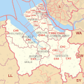 CH postcode area map.svg 1,000 × 1,000; 488 KB
-
 GL postcode area map.svg 1,000 × 1,000; 904 KB
-
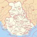
 HR postcode area map.svg 1,000 × 1,000; 548 KB
-
 LD postcode area map.svg 1,000 × 1,000; 373 KB
-
 LL postcode area inset map.svg 500 × 500; 80 KB
-
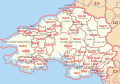
 LL postcode area map.svg 1,000 × 800; 1.18 MB
-
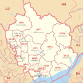 NP postcode area map.svg 1,000 × 1,000; 519 KB
-
 SA postcode area map.svg 1,000 × 700; 832 KB
-
 SY postcode area map.svg 1,000 × 1,000; 1.23 MB


