Category:Presbytère de Lay-Saint-Christophe
| Object location | | View all coordinates using: OpenStreetMap |
|---|
|
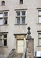
This building is classé au titre des monuments historiques de la France. It is indexed in the base Mérimée, a database of architectural heritage maintained by the French Ministry of Culture, under the reference PA00106056
|
presbytery located in Meurthe-et-Moselle, in France  | |||||
| Upload media | |||||
| Instance of | |||||
|---|---|---|---|---|---|
| Location | Lay-Saint-Christophe, canton of Malzéville | ||||
| Heritage designation |
| ||||
 | |||||
Media in category "Presbytère de Lay-Saint-Christophe"
The following 3 files are in this category, out of 3 total.
-
 Presbytère-StChristophe01.jpg 2,172 × 3,259; 4.63 MB
-
 Presbytère-StChristophe02.jpg 3,828 × 2,552; 6.97 MB
-
 Presbytère-StChristophe03.jpg 2,177 × 3,082; 4.36 MB

