Category:Promenade 11 (Ansbach)
| Object location | | View all coordinates using: OpenStreetMap |
|---|
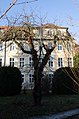
This is the category of the Bavarian Baudenkmal (cultural heritage monument) with the ID D-5-61-000-362 (Wikidata)
|
Deutsch: Ansbach - Promenade 11 - Wohnhaus. Dreigeschossiger traufständiger Satteldachbau, mit Zwerchhaus und Putzgliederung, von Johann David Steingruber, um 1740, anstelle des Husarenstalles. - Gartenzaun. Haustein und Schmiedeeisen, mit historisierenden Elementen, spätes 19. Jahrhundert.
building in Ansbach, Middle Franconia, Germany  | |||||
| Upload media | |||||
| Instance of | |||||
|---|---|---|---|---|---|
| Location | Ansbach, Middle Franconia, Bavaria, Germany | ||||
| Street address |
| ||||
| Has part(s) |
| ||||
| Heritage designation | |||||
 | |||||
Media in category "Promenade 11 (Ansbach)"
The following 2 files are in this category, out of 2 total.
-
 Ansbach, Promenade 11-001.jpg 3,264 × 4,928; 10.39 MB
-
 Promenade 11 Ansbach 20220106 0403.jpg 5,586 × 3,717; 18.3 MB
