Category:Public transport maps of Perth
Media in category "Public transport maps of Perth"
The following 15 files are in this category, out of 15 total.
-
 B15 Tram display, South Perth, January 2021 02.jpg 3,264 × 2,448; 2.87 MB
-
 MapMetronet.png 505 × 556; 163 KB
-
 Meltham station Transperth train system map.jpg 4,032 × 1,600; 1.17 MB
-
 Metronet-Western Australia.png 600 × 689; 187 KB
-
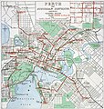
 Perth Railway map.png 2,188 × 2,797; 304 KB
-
 Perth Railway map.svg 2,694 × 570; 74 KB
-
 Perth tram map 1920.jpg 2,000 × 2,178; 541 KB
-
 Perth Tramways 1939.jpg 2,512 × 2,651; 5.57 MB
-
 Transperth B-series network map.jpg 4,032 × 3,024; 2.88 MB
-
 Transperth C-series mockup network map 2.jpg 4,032 × 3,024; 1.66 MB
-
 Transperth C-series mockup network map.jpg 3,933 × 1,747; 1.01 MB
-
 Transperth railway map.svg 516 × 810; 653 KB
-
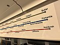
 Transperth system map at Butler Station.jpg 4,032 × 3,024; 1.62 MB
-
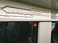
 Transperth system map at Redcliffe Station, Western Australia.jpg 3,965 × 3,024; 1.59 MB
-
 TransperthRailwayMap.svg 650 × 1,050; 142 KB


