Category:Puerto de Santiago
| Camera location | | View all coordinates using: OpenStreetMap |
|---|
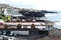
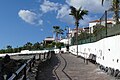
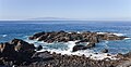
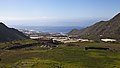
English: Pictures of Puerto de Santiago, a village belongs to the municipality Santiago del Teide on Tenerife, one of the islands of the Canary Islands in Spain. In Puerto de Santiago is the beach Playa de la Arena. Puerto de Santiago is not far of Los Gigantes, Acantilados de Los Gigantes and the harbour Puerto Deportivo Los Gigantes
human settlement in Tenerife, Santa Cruz de Tenerife Province, Canary Islands, Spain .jpg) | |||||
| Upload media | |||||
| Instance of | |||||
|---|---|---|---|---|---|
| Location | |||||
| Elevation above sea level |
| ||||
| Different from | |||||
 | |||||
Subcategories
This category has the following 8 subcategories, out of 8 total.
Media in category "Puerto de Santiago"
The following 50 files are in this category, out of 50 total.
-
 Barcelo Varadero.JPG 1,492 × 1,417; 345 KB
-
 Buildings on Tenerife near Playa Chica, Spain (48225234956).jpg 3,992 × 2,656; 4.41 MB
-

-
 Die Steilküste von Punta Negra auf Teneriffa, Spanien (48225286607).jpg 3,807 × 2,533; 4.38 MB
-
 Houses Puerto de Santiago P1580129.jpg 4,000 × 2,672; 4.04 MB
-
 Los Gigantes, Tenerife (4505704350).jpg 3,008 × 2,000; 434 KB
-
 Parque La Vigilia P1580203.jpg 4,000 × 2,672; 5.57 MB
-
 Puerto de Santiago - 01.jpg 2,048 × 916; 241 KB
-
 Puerto de Santiago - 02.jpg 2,048 × 884; 290 KB
-
 Puerto de Santiago - 03.jpg 2,048 × 1,203; 312 KB
-
 Puerto de Santiago - 04.jpg 2,048 × 860; 305 KB
-
 Puerto de Santiago - 05.jpg 2,048 × 1,125; 341 KB
-
 Puerto de Santiago - 06.jpg 2,048 × 1,113; 304 KB
-
 Puerto de Santiago - 07.jpg 2,048 × 1,044; 373 KB
-
 Puerto de Santiago - 08.jpg 2,048 × 671; 252 KB
-
 Puerto de Santiago - panoramio (1).jpg 5,184 × 3,456; 5.48 MB
-
 Puerto de Santiago - panoramio.jpg 5,184 × 3,456; 2.97 MB
-
 Puerto de Santiago DSCF0431.jpg 6,000 × 4,000; 13.28 MB
-
 Puerto de Santiago DSCF0432.jpg 6,000 × 4,000; 14.44 MB
-
 Puerto de Santiago DSCF0433.jpg 6,000 × 4,000; 13.32 MB
-
 Puerto de Santiago DSCF0434.jpg 6,000 × 4,000; 14.28 MB
-
 Puerto de Santiago P1580121.jpg 4,000 × 2,672; 5.65 MB
-
 Puerto de Santiago P1580125.jpg 4,000 × 2,672; 6.05 MB
-
 Puerto de Santiago P1580126.jpg 4,000 × 2,672; 5.76 MB
-
 Puerto de Santiago P1580130.jpg 4,000 × 2,672; 6.07 MB
-
 Puerto de Santiago P1580131.jpg 4,000 × 2,672; 5.7 MB
-
 Puerto de Santiago P1580132.jpg 4,000 × 2,672; 5.74 MB
-
 Puerto de Santiago P1580133.jpg 4,000 × 2,672; 5.76 MB
-
 Puerto de Santiago P1580135.jpg 4,000 × 2,672; 6.25 MB
-
 Puerto de Santiago P1580136.jpg 4,000 × 2,672; 6.11 MB
-
 Puerto de Santiago P1580137.jpg 4,000 × 2,672; 5.9 MB
-
 Puerto de Santiago P1580146.jpg 4,000 × 2,672; 4.84 MB
-
 Puerto de Santiago P1580201.jpg 4,000 × 2,672; 5.48 MB
-
 Puerto de Santiago P1580202.jpg 4,000 × 2,672; 5.44 MB
-
 Puerto de Santiago P1580250.jpg 4,000 × 2,672; 5.87 MB
-

-
 Puerto de Santiago, Tenerife, España, 2012-12-16, DD 04.jpg 5,090 × 2,689; 4.05 MB
-
 Puerto de Santiago, Tenerife, España, 2012-12-16, DD 05.jpg 5,435 × 2,812; 5.48 MB
-
 Puerto de Santiago, Tenerife, España, 2012-12-16, DD 06.jpg 5,338 × 3,337; 6.03 MB
-
 Puerto deportivo de Los Gigantes - panoramio.jpg 2,592 × 1,944; 302 KB
-
 Puerto santiago.JPG 3,264 × 2,448; 3.64 MB
-
 Purto de Santiago - panoramio.jpg 2,592 × 1,728; 347 KB
-

-
 Speelplaats Puerto de Santiago P1580374.jpg 4,000 × 2,672; 5.61 MB
-
 Tenerife Tamaimo los gigantes IMG 4726.JPG 5,184 × 3,456; 6.06 MB
-
 Tenerife Tamaimo los gigantes IMG 4727.JPG 5,184 × 3,456; 7.19 MB
-
 Vista de Puerto de Santiago, Santa Cruz de Tenerife, España, 2012-12-16, DD 01.jpg 5,616 × 3,166; 7.09 MB
-
 Vista de Puerto de Santiago, Santa Cruz de Tenerife, España, 2012-12-16, DD 02.jpg 5,616 × 3,744; 6.51 MB
-
 Vista de Puerto de Santiago, Santa Cruz de Tenerife, España, 2012-12-16, DD 03.jpg 5,334 × 2,658; 4.3 MB
-
 Vista de Puerto de Santiago, Santa Cruz de Tenerife, España, 2012-12-16, DD 04.jpg 5,616 × 3,032; 5.69 MB

.jpg)
.jpg)
.jpg)

.jpg)


.jpg)


