Category:Pumperloch (A 17)
cultural heritage monument in Etzelwang, Amberg-Sulzbach, Upper Palatinate, Bavaria, Germany _02.jpg) | |||||
| Upload media | |||||
| Instance of |
| ||||
|---|---|---|---|---|---|
| Location | Etzelwang, Amberg-Sulzbach, Upper Palatinate, Bavaria, Germany | ||||
| Heritage designation |
| ||||
 | |||||
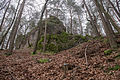
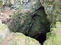
Deutsch: Die Karsthöhle Pumperloch (HFA-Katasternummer: A 17) befindet sich im oberpfälzischen Landkreis Amberg-Sulzbach, etwa 960 Meter westsüdwestlich der Ortsmitte der Ortschaft Gerhardsberg in der Gemeinde Etzelwang im Bundesland Bayern in Deutschland. Der zehn Meter tiefe Einstigsschacht der Höhle führt in eine große Höhlenhalle. Sie ist als Naturdenkmal ausgewiesen. Das Pumperloch ist auch als Doline mit der Nummer 6435/D021 im Dolinenkataster Nordbayern bezeichnet.
| Object location | | View all coordinates using: OpenStreetMap |
|---|
Media in category "Pumperloch (A 17)"
The following 7 files are in this category, out of 7 total.
-
 Pumperloch (A 17) 01.jpg 5,472 × 3,648; 12.99 MB
-
 Pumperloch (A 17) 02.jpg 5,472 × 3,648; 18.63 MB
-
 Pumperloch (A 17) 03.jpg 3,648 × 5,472; 18.55 MB
-
 Pumperloch (A 17) 04.jpg 3,648 × 5,472; 18.08 MB
-
 Pumperloch (A 17) 05.jpg 5,472 × 3,648; 18 MB
-
 Pumperloch (A 17) 06.jpg 5,472 × 3,648; 20.66 MB
-
 Pumperloch (A17) - panoramio.jpg 1,600 × 1,200; 300 KB
_01.jpg)
_03.jpg)
_04.jpg)
_05.jpg)
_06.jpg)
_-_panoramio.jpg)