Category:Queensland estate maps
Maps and plans of land subdivision for new housing estates in Queensland.
Media in category "Queensland estate maps"
The following 87 files are in this category, out of 87 total.
-
 Domain at Lutwyche Estate Map.jpg 2,589 × 4,000; 2.24 MB
-
 Estate map for Isistown, Isis Queensland, 1886.tiff 2,476 × 4,000; 28.36 MB
-
 Estate Map of Glenlyon Gardens Ashgrove Brisbane Queensland.jpg 4,471 × 6,000; 12.57 MB
-
 German Station at Nundah Estate Map.jpg 4,000 × 3,099; 15.42 MB
-
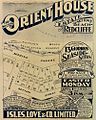
 Orient House at Suttons Beach Estate Map.jpg 4,803 × 6,000; 3.76 MB
-
 Rainworth Estate, Paddington, map 1925.jpg 5,947 × 6,000; 9.06 MB
-
 Sea Spray at Woody Point Estate Map.jpg 3,806 × 6,000; 6.41 MB
-

-
 StateLibQld 1 109044 Estate map for New Farm, Brisbane, Queensland, ca.1887.jpg 1,000 × 648; 119 KB
-

-
 StateLibQld 1 129418 Map of the St. Lucia Estate, Brisbane, 1885.jpg 1,000 × 646; 120 KB
-
 StateLibQld 1 130347 Estate map for sale of land in Moggill, 1888.jpg 691 × 1,000; 114 KB
-

-

-
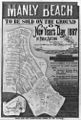 StateLibQld 1 130843 Estate map of Manly Beach, Manly,1887.jpg 675 × 1,000; 119 KB
-
 StateLibQld 1 131175 Estate map for Moorooka Park, Moorooka, Brisbane, 1889.jpg 626 × 1,000; 139 KB
-

-

-

-

-
-

-

-

-
 StateLibQld 1 262840 Estate map of Kangaroo Point, Brisbane, Queensland.jpg 722 × 1,000; 85 KB
-

-
 StateLibQld 1 262856 Estate map of Lilly Estate, Toowoomba, Queensland, 1902.jpg 665 × 1,000; 122 KB
-

-

-

-
 StateLibQld 1 262976 Estate map of Hermit Park, Townsville, Queensland, 1884.jpg 625 × 1,000; 146 KB
-

-

-
 StateLibQld 2 107716 Coorparoo Heights Estate map, 1916.jpg 751 × 1,000; 167 KB
-
 StateLibQld 2 128185 Avondale Estate map, Coorparoo, 1887.jpg 1,000 × 636; 117 KB
-

-

-

-
-

-
-
 StateLibQld 2 191855 Estate map for Pacific Ocean Estate, Southport, 1915.jpg 636 × 1,000; 137 KB
-
 StateLibQld 2 196159 Racecourse Estate Map, Coorparoo, Brisbane, 1919.jpg 1,000 × 808; 151 KB
-

-
 StateLibQld 2 200851 Estate map of the Vaughan Estate, Redcliffe, 1890-1900.jpg 793 × 1,000; 154 KB
-
 StateLibQld 2 202459 Plan of Sefton Estate, Clayfield, Brisbane.jpg 1,000 × 675; 142 KB
-

-
-

-

-

-
 StateLibQld 2 262776 Estate map of town of Nerang, Queensland, 1890.jpg 751 × 1,000; 68 KB
-

-
 StateLibQld 2 262792 Estate map for Isistown, Isis, Queensland, 1886.jpg 619 × 1,000; 150 KB
-

-

-

-

-

-
-

-
 StateLibQld 2 262864 Map of Eldernell Estate Hamilton, Brisbane, 1890.jpg 622 × 1,000; 98 KB
-
 StateLibQld 2 262868 Estate map of the town of Eumundi, Queensland, 1906.jpg 1,000 × 740; 69 KB
-

-

-

-

-

-

-

-

-
 StateLibQld 2 262980 Estate map of Coolangatta, Queensland, 1914.jpg 775 × 1,000; 187 KB
-

-

-
-

-

-

-

-

-

-
-

-

-

-
 StateLibQld 2 263096 Estate map of Walkerville, Cairns, Queensland, 1884.jpg 1,000 × 629; 141 KB
-
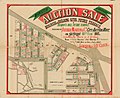
 StateLibQld 2 389189 Auction sale notice of Crown lands, Tweed Heads, 1927.jpg 673 × 1,000; 132 KB


