Category:Römische Villa bei Rians
| Object location | | View all coordinates using: OpenStreetMap |
|---|
 | |||||
| Upload media | |||||
| Instance of | |||||
|---|---|---|---|---|---|
| Location | Rians, canton of Rians | ||||
 | |||||
Media in category "Römische Villa bei Rians"
The following 3 files are in this category, out of 3 total.
-
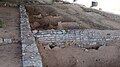 Gebäudestruktur der Villa romaine bei Rians, Var, 2023.jpg 4,000 × 2,250; 2.79 MB
-
 Grundmauern der Villa romaine bei Rians, Var, 2023.jpg 4,000 × 2,250; 3.91 MB
-
 Reihen von Weingefässen aus Ton in der Villa romaine bei Rians, Var, 2023.jpg 4,000 × 2,250; 4.9 MB

